
Best Places to Visit in Washington State

The Evergreen State is a true gem of the Pacific Northwest with dramatic mountains, lush forests, sparkling coastlines, and vibrant cities all rolled into one. After exploring time and again and from my month-long stay in Seattle, here are the places in Washington I keep coming back to.
What are the best places to visit in Washington State? I say, land in Seattle, then drive to Snohomish, Kirkland and Mukilteo. Those are just the best and will give you a taste of this beautiful state in just a few days. Further out from Seattle (you will need a weekend for each!), my favorite destinations are Friday Harbor, Spokane, Port Angeles, Walla Walla, Ellensburg, and Vancouver, WA.
1. Snohomish
Distance from Seattle: 40 minutes
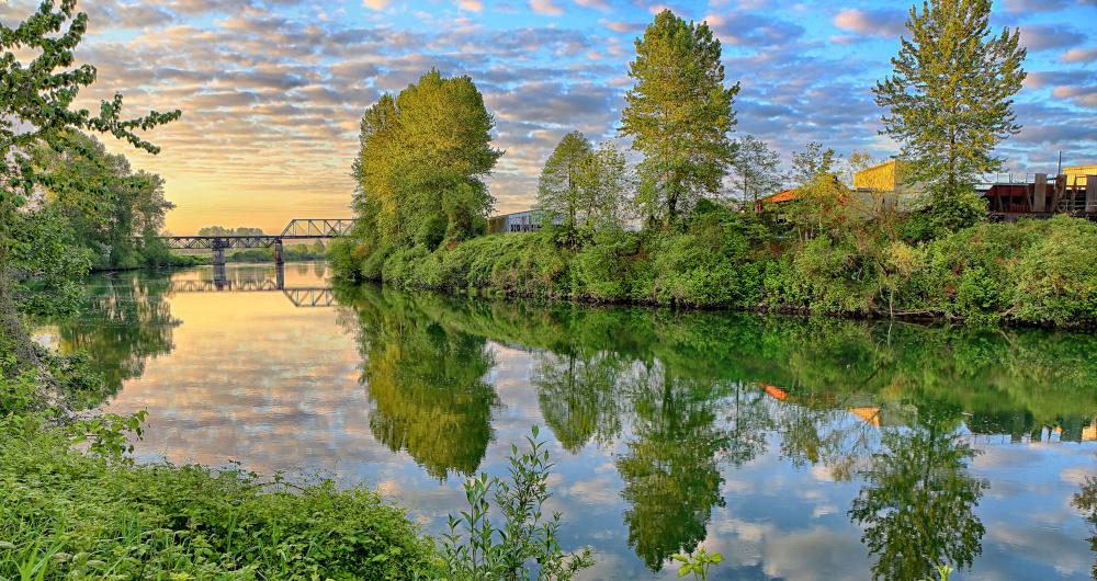
I thought that Snohomish has the charm of a small riverside town while still feeling very connected to the Pacific Northwest’s big landscapes. I heard it called the “Antique Capital of the Northwest,” and I could see whey. Snohomish's historic downtown is a delightful stretch of old brick buildings, quirky shops, and family-owned restaurants.
Be ready for how quickly the scenery shifts. One moment you’re exploring boutiques and cafés, the next you’re surrounded by farmland, river trails, and mountain views.
There’s an easygoing energy here, with the Snohomish River flowing along the edge of town and the Cascade foothills rising in the distance. On a sunny day, hot air balloons often drift across the sky. It’s a place that blends nostalgia with natural beauty, a hub of history and heritage paired with open-air adventure.
Whether you’re exploring downtown, hiking nearby, or sipping coffee by the river, it feels like a perfect spot to slow down while staying close to Seattle.
What to do in Snohomish in two days:
- Wander through Historic Downtown Snohomish. There are plenty of antique shops, bookstores, and cafés.
- Walk or bike the Centennial Trail, a 30-mile paved path connecting through forests and farmland
- Visit the Snohomish Riverfront Trail for peaceful views along the water
- Have brunch at the Grilla Bites café or a cozy bakery in town
- Take a scenic hot air balloon ride for sweeping views of the Cascades and valley
- Watch a sunset from Lord Hill Regional Park
2. Spokane
Distance from Seattle: 4 hours 30 minutes
Spokane’s setting in the Inland Northwest, 4.5 hours from Seattle, makes it a playground for hikers and bikers. I cycled part of the Centennial Trail (40 miles along the Spokane River, free access), then hiked Riverside State Park’s Bowl and Pitcher Trail (2 miles, $10 day pass) with basalt rock formations and river rapids.
I plan to go back in winder. I heard that Mount Spokane State Park
That night, we stayed at Ruby River Hotel ($185), right on the river with a pool and easy trail access.
I’ll admit, I didn’t expect to love Spokane as much as I did. But the moment I stood by the roaring Spokane Falls in the middle of downtown, I felt something shift. It was raw, unfiltered beauty, tucked right into an urban heartbeat.
Quieter than Seattle but full of surprises, Spokane gave me space to slow down while still feeling plugged in. I remember thinking, “This place is more alive than people give it credit for.”
What to do in Spokane in two days:

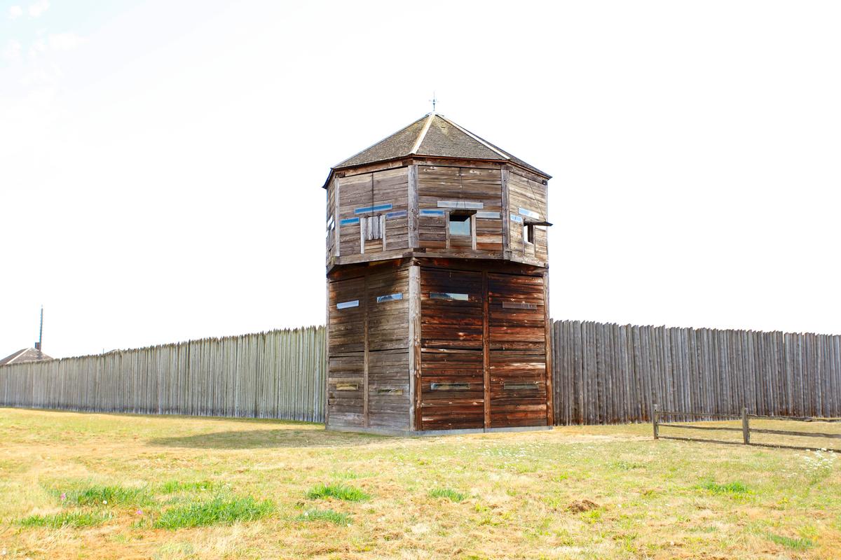
3. Port Angeles
Distance from Seattle: 2 hours 45 minutes (plus a short ferry ride if coming from downtown)
From Seattle, I drove about 2 hours 40 minutes northwest (85 miles via WA-104 and US-101, including a Hood Canal Bridge crossing) to Port Angeles, a harbor town of about 20,000 residents.
Once a logging hub, today it’s the gateway to Olympic National Park. I walked the Port Angeles Waterfront Trail (about 8 miles total, free) with views across the Strait of Juan de Fuca toward Canada, then stopped at the small but fascinating Feiro Marine Life Center ($5 admission).
We stayed at the historic Red Lion Hotel on the waterfront ($175), overlooking the ferry terminal.
I found Port Angeles to be welcoming, with a mix of maritime heritage and mountain-town energy. Whether you’re sipping coffee by the harbor, exploring tidepools, or heading up Hurricane Ridge for sweeping views, it feels like a perfect launching point to experience the Olympic Peninsula’s beauty.
What to do in Port Angeles in two days:
- Walk along the Port Angeles Waterfront Trail with views of the harbor and mountains
- Explore the Feiro Marine Life Center to learn about local sea life
- Drive up to Hurricane Ridge in Olympic National Park for panoramic mountain vistas
- Visit Lake Crescent for kayaking, swimming, or hiking to Marymere Falls
- Have dinner at Kokopelli Grill
- Take a side trip to Rialto Beach or Second Beach to experience the Pacific coast
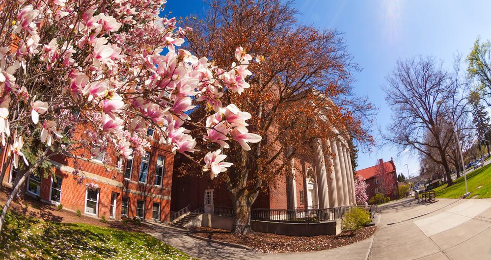
4. Seattle
Distance from Portland: 3 hours
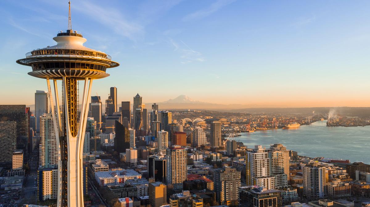
Seattle is the kind of city that feels both dynamic and deeply tied to its natural setting. Skyscrapers rise over Elliott Bay, ferries glide across the water, and snowcapped Mount Rainier stands like a backdrop to everyday life. The rhythm here is fast enough to feel exciting, yet softened by constant reminders of nature at the edge of every view.
From Portland, I drove about 3 hours north into Seattle, a city of roughly 750,000 residents (metro area 4.1 million). I started at Pike Place Market (founded 1907, free entry), wandering through flower stalls and fishmongers tossing salmon.
Then I toured the historic Pioneer Square district, home to brick buildings from the late 1800s, and ducked into the Underground Tour ($25) to see the city’s hidden tunnels. Later, I rode the elevator up the Space Needle (605 feet tall, $35 admission) for sunset views over Elliott Bay. Dinner was cedar-plank salmon ($32) at a waterfront restaurant.
We stayed at the historic Mayflower Park Hotel ($245), which has been welcoming guests since 1927.
I began at Nossa Familia Coffee's Seattle outpost, ordering a smooth Americano and a warm cheddar-chive biscuit. The coffee was rich and earthy, the biscuit savory and crumbly, and I lingered as long as I could.
Later, I wandered into the Center on Contemporary Art (CoCA), where bold installations filled the quiet rooms. One piece, paint streaked across deconstructed wood, made me stop and whisper, “I didn’t know art could ache like this.” I followed the mood into the afternoon, strolling through Occidental Square and the waterfront.
Dinner at Toulouse Petit brought warmth: a bowl of wild mushroom gnocchi, soft and earthy, with a hint of sage and butter that clung to my lips as the streetlights blinked on.
I also enjoyed: Dinner at Tulio, tucked beneath the vintage Hotel Vintage, where the lights were low and the food felt like a hug. I ordered the wild boar ragù. It arrived earthy and rich, layered over handmade pappardelle that soaked up every bit of the rosemary-laced sauce.
What to do in Seattle in two days:
- Stroll through Pike Place Market, sampling local foods and watching the fishmongers
- Visit the Seattle Art Museum or the Museum of Pop Culture for culture and creativity
- Ride to the top of the Space Needle for panoramic views of the city and mountains
- Walk along the Seattle Waterfront and take a ferry ride across Puget Sound
- Explore neighborhoods like Capitol Hill for cafés, bookstores, and nightlife
- Enjoy sunset at Kerry Park, one of the city’s most iconic viewpoints

5. Walla Walla
Distance from Seattle: 4 hours 30 minutes
Walla Walla feels like a small town wrapped in vineyards, history, and sunshine. Known for its world-class wine scene, it has the kind of charm that mixes farmland warmth with sophisticated tasting rooms and restaurants. The downtown streets are lined with boutiques, cafés, and historic brick buildings that give it a timeless quality.
We stayed at the Marcus Whitman Hotel ($195), a 1928 landmark with old-world charm right downtown.The landscape here is wide open with rolling wheat fields, golden hills, and endless skies that glow at sunset. It’s an agricultural valley at heart, but one that has blossomed into a hub for winemakers, food lovers, and travelers seeking a slower pace. There’s a balance between refinement and simplicity that makes it easy to settle in.
I found Walla Walla to be both inviting and quietly elegant, where hospitality is genuine and the scenery is soothing. Whether you’re sipping wine, walking historic Main Street, or taking a scenic drive through the valley, it feels like a destination that blends the best of rural Washington with a touch of cosmopolitan flair.
What to do in Walla Walla in two days:
- Stroll along Main Street to explore shops, cafés, and tasting rooms
- Visit a few of the local wineries, from family-run vineyards to acclaimed estates
- Walk through the Whitman College campus, known for its art and landscaping
- Explore the Fort Walla Walla Museum for a look at regional history
- Dine at a farm-to-table restaurant featuring local ingredients
- Take a scenic drive through the Blue Mountains or the golden wheat fields at sunset

6. Kirkland
Distance from Seattle: 20 minutes
Kirkland sits along the eastern shore of Lake Washington, offering a mix of waterfront charm and lively neighborhood energy. With walkable streets, parks that spill right to the water’s edge, and a strong local arts scene, it feels like a place where the lake sets the tone for daily life. You’ll find people out on boats, strolling the waterfront, or enjoying a meal at a patio café with views across the water to Seattle’s skyline.
Kirkland is close to the bustle of the city, yet it has a relaxed, small-town feel. Downtown is compact and filled with shops, restaurants, and galleries, while nearby neighborhoods stretch into leafy residential streets. The lakefront parks are the real heart of the city, drawing locals and visitors alike for swimming, picnics, and sunsets.
We stayed at The Heathman Hotel ($225), a stylish boutique in the heart of downtown.Whether you’re here for the waterfront, the art, or simply to soak in a slower pace with lake views, it’s a spot that feels vibrant but never overwhelming.
What to do in Kirkland in two days:
- Walk through downtown Kirkland to browse boutiques, galleries, and cafés
- Relax at Marina Park, a waterfront hub with a beach, picnic areas, and sunset views
- Stroll the Lake Washington waterfront trail for scenic views
- Explore the Kirkland Arts Center or local galleries
- Have dinner at a lakeside restaurant like Anthony’s HomePort
- Take a boat tour or paddleboard on Lake Washington to see the shoreline from the water

7. Friday Harbor, San Juan Island
Distance from Seattle: 3 hours (including ferry ride)
Friday Harbor feels like stepping into a postcard, a harborside town where boats line the marina, orcas swim offshore, and island life moves at a gentle pace. As the hub of San Juan Island, it’s compact and walkable, filled with art galleries, cafés, and waterfront restaurants, all wrapped in stunning views of the Salish Sea.
From Seattle, I drove about 1 hour 45 minutes north (90 miles via I-5) to Anacortes, then boarded the Washington State Ferry (1 hour, $15 walk-on or ~$25 per car + driver) across the Salish Sea to Friday Harbor, the main town on San Juan Island (population ~2,400).
I wandered the compact, walkable downtown filled with galleries, shops, and cafés, then visited the San Juan Historical Museum ($10 admission) to learn about the island’s pioneer past. We stayed at the historic Friday Harbor House ($295), perched above the marina with sunset views of the ferries gliding in.
The ferry ride in felt like part of the story, mist on the water, gulls overhead, and distant islands coming into view one by one. When we docked in Friday Harbor, I stepped off into a town that felt both cozy and quietly refined. The streets were walkable, the harbor just steps from everything, and there was salt in the air that made me instantly slow down.
What to do in Friday Harbor in two days:
8. Mukilteo
Distance from Seattle: 35 minutes
Mukilteo sits quietly on the edge of Puget Sound, where ferries glide back and forth to Whidbey Island and sunsets paint the water in gold and orange. Its a a small waterfront city with a rich history, most visible in the striking white Mukilteo Lighthouse that has guided ships since the 1900s. The atmosphere here is calm and coastal, with parks, beaches, and trails all within a short walk of downtown.
What makes Mukilteo special is its blend of maritime heritage and everyday Northwest beauty. Locals gather on the beach to watch ferries depart, families picnic on grassy hillsides, and visitors wander the waterfront with an ice cream in hand. Beyond the shoreline, you’ll find wooded trails, golf courses, and easy access to the rest of Snohomish County.
I found Mukilteo to be both laid-back and scenic — a place where the pace slows as soon as you reach the waterfront. Whether you’re here for history, a ferry ride, or simply to watch the sun slip behind the Olympic Mountains, it feels like a classic Puget Sound escape.
What to do in Mukilteo in two days:
- Visit the historic Mukilteo Lighthouse Park for beach walks and sunset views
- Watch the Whidbey Island ferry come and go, or take the short ride across
- Enjoy fresh seafood at Ivar’s Mukilteo Landing right on the water
- Explore the nearby Japanese Gulch Trail for forested hiking and biking
- Play a round at Harbour Pointe Golf Club with sweeping water views
- Relax with coffee or ice cream along the waterfront, soaking up the harbor atmosphere
9. Ellensburg, WA
Distance from Seattle: 2 hours
Ellensburg is a true Central Washington gem, a college town with historic roots and open skies. Set in the Kittitas Valley, it has a mix of frontier history, farmland charm, and youthful energy from Central Washington University. Downtown is filled with 19th-century brick buildings, galleries, cafés, and shops that give it both character and warmth.
We stayed at the Hotel Windrow ($185), a boutique hotel blending modern amenities with rustic style.
The valley landscape stretches wide, with rolling hills, farmland, and mountains in the distance. Summers bring sunshine and festivals, while fall glows with golden fields. There’s a sense of space here — whether you’re wandering downtown, driving country roads, or exploring the Yakima River Canyon just south of town.
Whether you’re here for a rodeo, a quiet weekend of exploring, or just to enjoy the slower rhythm of a small Washington town, it has a way of feeling both authentic and refreshing.
What to do in Ellensburg in two days:
- Walk through historic downtown Ellensburg, browsing shops, cafés, and galleries
- Visit the Kittitas County Historical Museum for a glimpse into local history
- Explore the CWU campus, with its public art, museums, and green spaces
- Drive the scenic Yakima River Canyon for dramatic views and hiking spots
- Dine at a local favorite like The Pearl Bar & Grill or a casual pub downtown
- Catch sunset over the valley or take a short hike into the nearby foothills
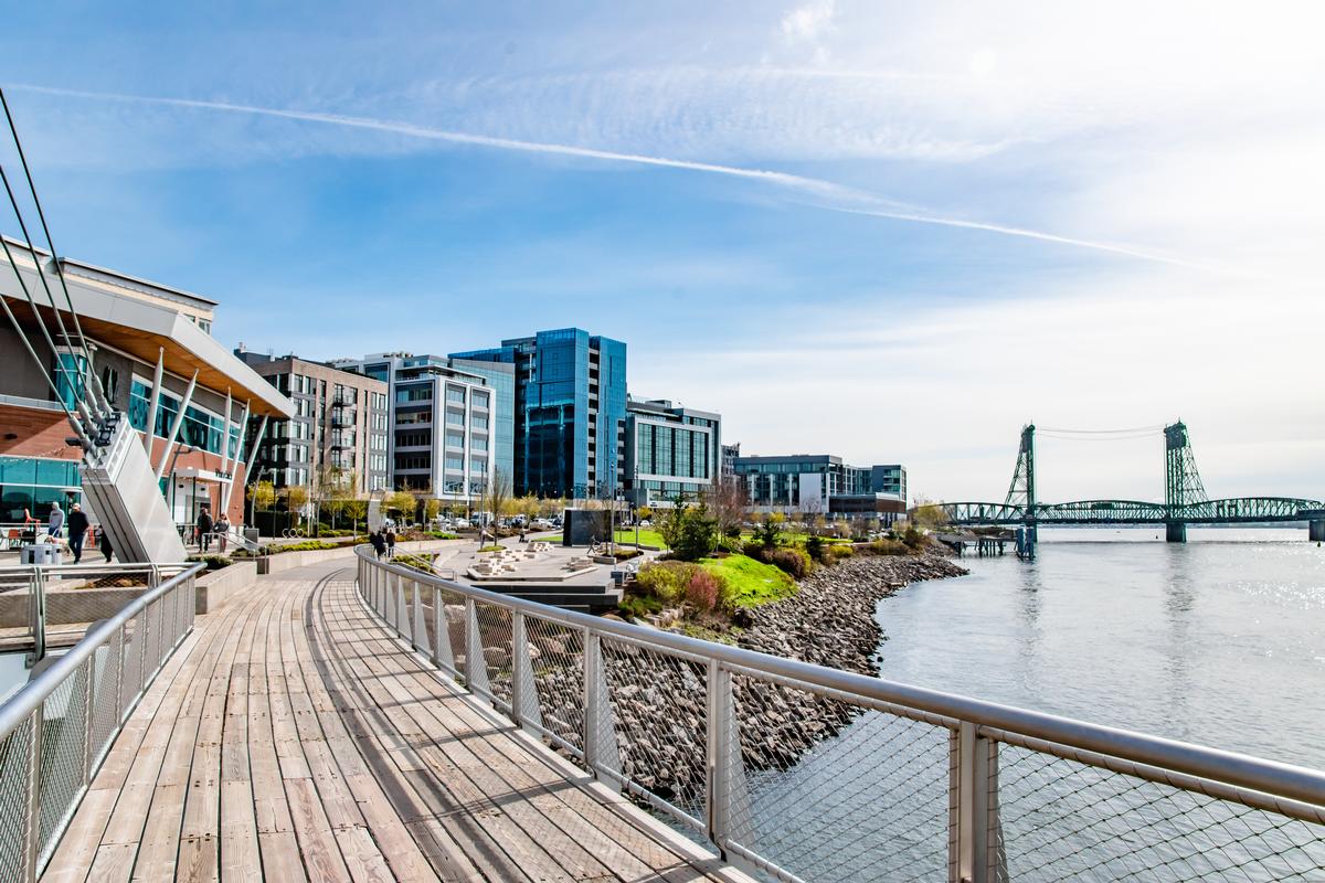
10. Vancouver, Washington
Distance from Portland: 15 minutes
Vancouver, Washington feels like Portland’s quieter neighbor across the Columbia River, but it carries its own deep history and Northwest character. When I lived here as a local, I enjoyed this easy-to-visit city a lot.
A few times we stayed at Hotel Indigo Vancouver ($210), a modern boutique right on the waterfront. The views were relaxing and we didn't have to drive if we didn't feel like it to enjoy the area.
What to do in Vancouver in two days:
Conclusion
From coastal towns and island harbors to mountain gateways and river valleys, Washington offers a remarkable range of experiences packed into one state. Each place has its own rhythm. Together, they paint a picture of a region where nature and community are always intertwined.
In the end, Washington isn’t just one landscape or one story, it’s many. And whether you come for a weekend getaway or a longer exploration, each destination leaves you with a piece of the Pacific Northwest’s beauty and spirit to carry home.
Booking Checklist
1. Book Your Flight - I use Expedia because I like their mobile app with my itinerary. They've helped me re-book flights on many occasions. Once you reach their Gold tier, support is especially good.
2. Book Your Hotel - I use Booking.com or Expedia, depending on my destination.
3. Book Your Rental Car - I use Expedia.
4. Book your tours on Viator or Get Your Guide.
