

Want wide-open desert beauty, colorful canyons, and peaceful outdoor escapes? In this post, I’ll share the red rock canyons, desert trails, and shimmering lakes in Nevada state parks—where rugged beauty and wide-open silence define the spirit of the West. These parks serve up stunning landscapes, quiet getaways, and family-friendly adventures close to home.
😍 If you are in a hurry, I recommend:
Unique Nevada State Parks
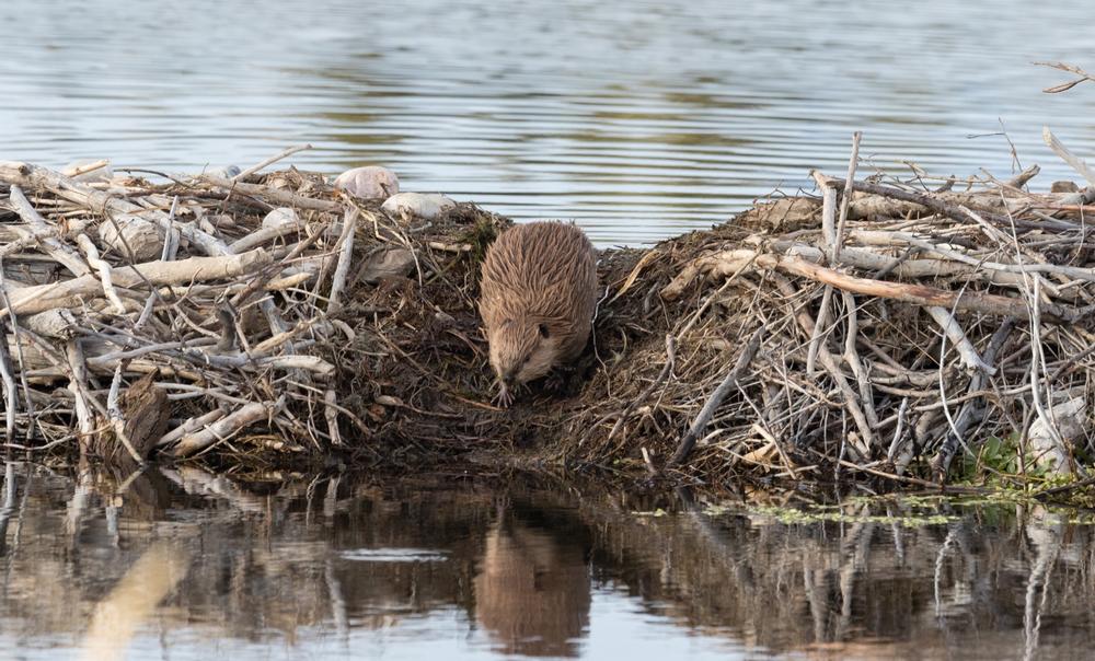
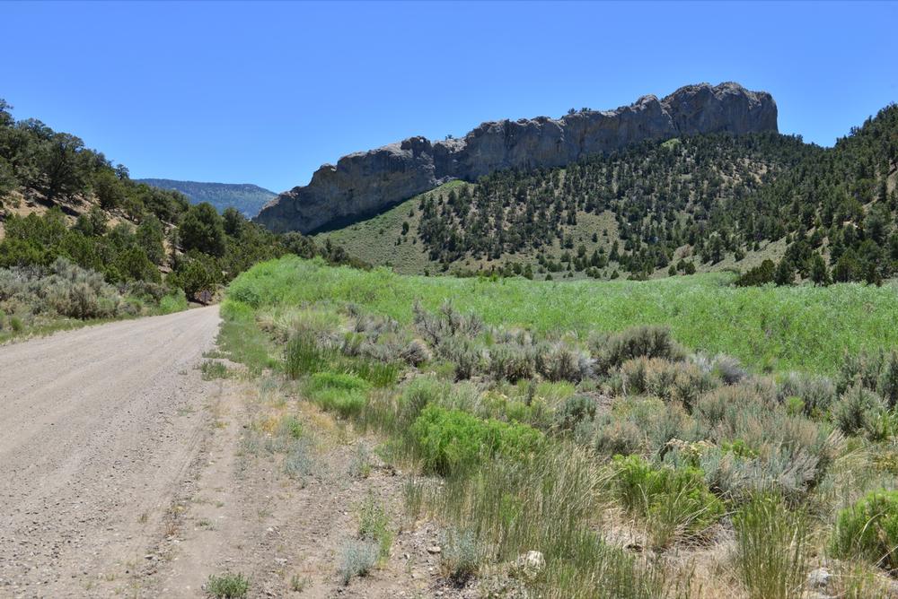
1. Beaver Dam - a 1-hour drive from Panaca, NV
♥
"Fish, camp, and enjoy scenic hikes along the quiet streams."
Location:
Panaca, NVHighlights:
If you're craving a true escape into wild, untouched nature, Beaver Dam State Park is your spot. It’s tucked away in Nevada’s remote east corner—perfect for unplugging and reconnecting with the outdoors.We Recommend This For:
Adventurers, solitude seekers, wildlife watchers, campers, and anyone looking to explore Nevada's hidden natural gems.What we Love:
Rugged canyons, volcanic rock formations, peaceful fishing spots, wildlife galore, and the historic remains of Hamblin Ranch.- Explore four miles of wooded canyon trails lined with waterfalls, springs, and dramatic volcanic outcrops.
- Fish for rainbow trout in Beaver Dam Wash—an ideal quiet spot for anglers.
- Camp under dark night skies at one of the park’s primitive campsites nestled in scenic surroundings.
- Spot diverse wildlife including deer, jackrabbits, bobcats, and the occasional mountain lion in this designated Watchable Wildlife Area.
Cost:
$10 per vehicle for a 1-day pass; annual and multi-day passes availableDistance from Panaca, NV:
About 34 miles east—expect a 1-hour drive on partially unpaved roads.How to Get to Beaver Dam:
From Panaca, travel east on Nevada State Route 319, then turn onto Beaver Dam Road and follow signs for about 30 miles on a mix of paved and gravel roads. A high-clearance vehicle is recommended.Address:
Beaver Dam, Panaca, NV 89042Phone: 775-728-4460
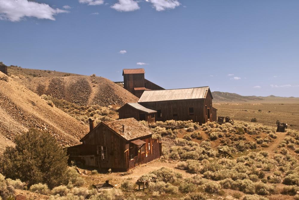
2. Berlin-Ichthyosaur - a 1.5-hour drive from Austin, NV
💕
"Discover ancient fossils and explore a preserved ghost town."
Location:
Austin, NVHighlights:
If you're into fossils, ghost towns, or off-the-grid adventures, Berlin-Ichthyosaur State Park is a treasure trove. This high-elevation park blends Nevada's prehistoric past with its Wild West history in one unforgettable spot.We Recommend This For:
History buffs, paleontology lovers, ghost town explorers, and campers looking for quiet, scenic escapes.What we Love:
The well-preserved ghost town of Berlin, the fascinating ichthyosaur fossil site, and guided tours that bring ancient and recent history to life.- Tour the authentic 1890s mining town of Berlin, preserved in a hauntingly beautiful state of arrested decay.
- Discover Nevada’s state fossil at the onsite ichthyosaur fossil shelter—home to one of the largest concentrations of these prehistoric marine reptiles.
- Hike the scenic, high desert trails that wind through the Shoshone Mountains, offering panoramic views and solitude.
- Camp under the stars at one of the park’s primitive sites nestled at 7,000 feet elevation.
Cost:
$5 per vehicle for a day-use pass; camping fees are additionalDistance from Austin, NV:
Approximately 60 miles southeast—expect a 1.5-hour drive via State Route 844.How to Get to Berlin-Ichthyosaur:
From Austin, NV, head southeast on US-50, then turn south onto State Route 844. Follow signs to the park entrance; the road is paved but remote, so fill up on gas and bring supplies.Address:
Berlin-Ichthyosaur, State Route 844, Austin, NV 89310Phone: 775-964-2440
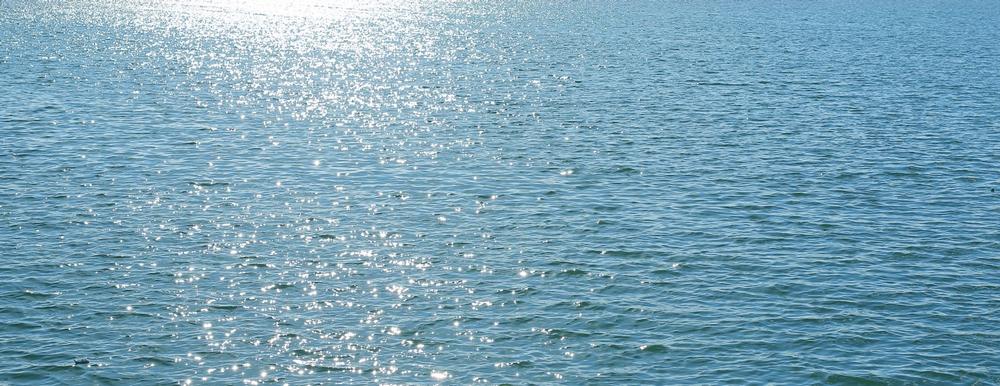
3. Big Bend of the Colorado
I like:
"Relax by the river and enjoy kayaking and swimming."
Location:
Laughlin, NVHighlights:
If you're dreaming of sunshine, sandy beaches, and cool river water, Big Bend of the Colorado is calling. This laid-back park is perfect for a weekend of swimming, fishing, and relaxing in Nevada’s southernmost corner.We Recommend This For:
Families, birdwatchers, swimmers, boaters, RV campers, and anyone looking to pair outdoor fun with nearby nightlife.What we Love:
Sandy shoreline with easy water access, year-round cool river temps, and the bonus of Laughlin’s restaurants and casinos just minutes away.- Swim in the clear waters of the Colorado River, ideal for cooling off on hot desert days.
- Fish along the shore or by boat—popular catches include catfish and bass.
- Watch birds like coots, herons, mallards, and geese, especially in the early morning hours.
- Camp with ease at full-hookup RV sites or shaded picnic areas just steps from the river.
Cost:
$10 per vehicle for day use; additional fees for camping and RV hookupsDistance from Laughlin, NV:
Located right within Laughlin city limits—only minutes from the town center.How to Get to Big Bend of the Colorado:
Head south on Needles Highway from central Laughlin. The park entrance is well-marked and located at 4220 Needles Hwy, just past the casino district.Address:
Big Bend of the Colorado, 4220 Needles Hwy, Laughlin, NV 89209Phone: 702-298-1859
Romantic Nevada State Parks
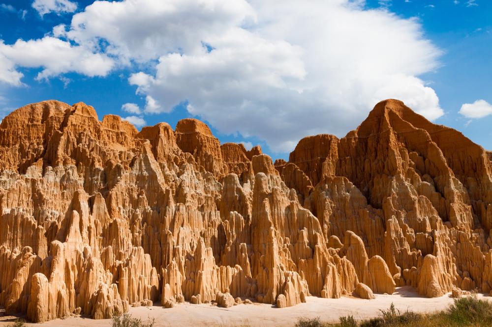
4. Cathedral Gorge State Park
♥
"Hike through dramatic slot canyons and admire unusual rock formations."
Location:
Panaca, NVHighlights:
If you're chasing otherworldly landscapes and Insta-worthy scenery, Cathedral Gorge is a must-see. These sculpted clay spires and slot canyons feel like stepping into another planet—right in Nevada.We Recommend This For:
Photographers, geology lovers, families, hikers, and anyone looking for a unique desert day trip or camping adventure.What we Love:
The surreal, cathedral-like formations, narrow slot canyons perfect for exploring, and peaceful desert sunrises from the campground.- Hike short scenic trails like the Miller Point Trail or explore the narrow slot canyons carved into bentonite clay.
- Photograph the golden hour light as it dances across the unique textures and spires—an unforgettable sight.
- Camp under star-filled skies with spacious sites and access to picnic shelters and restrooms.
- Learn about the park’s ancient geological history through interpretive signs and the onsite visitor center.
Cost:
$5 per vehicle for day use; additional camping fees applyDistance from Panaca, NV:
Just 1 mile north—barely a 5-minute drive from town.How to Get to Cathedral Gorge:
From Panaca, drive north on State Route 93 and follow signs to the park entrance on Cathedral Gorge State Park Road. It’s an easy and scenic route.Address:
Cathedral Gorge State Park, 111 Cathedral Gorge State Park Road, Panaca, NV 89042Phone: 775-728-4460
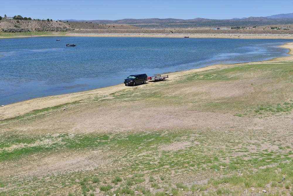
5. Cave Lake State Park
Among my top 5:
"Fish for trout and explore peaceful nature trails."
Location:
Ely, NVHighlights:
If you love cool mountain lakes, fresh air, and year-round adventure, Cave Lake is your perfect high-elevation hideaway. Whether you're into summer paddling or winter snow sculpting, this park has it all.We Recommend This For:
Outdoor enthusiasts, families, anglers, winter sports lovers, and anyone craving a scenic mountain escape.What we Love:
The clear alpine lake, wide range of seasonal activities, panoramic views, and peaceful campsites tucked into the high desert landscape.- Fish for rainbow and German brown trout in the 32-acre lake or go craw-dadding along the shore.
- Hike scenic mountain trails that wind through the Schell Creek Range with photo-worthy vistas at every turn.
- Play in the snow during winter—try cross-country skiing, ice fishing, or join in the growing snow sculpting tradition.
- Camp in well-maintained sites with picnic tables, restrooms, and beautiful views of the lake and surrounding peaks.
Cost:
$5 per vehicle for day use; additional fees apply for camping and boatingDistance from Ely, NV:
About 5 miles southeast—an easy 10-minute drive.How to Get to Cave Lake:
From Ely, head southeast on US Highway 93 and follow signs to Success Summit. Turn onto Cave Lake Road and continue to the park entrance.Address:
Cave Lake State Park, US Highway 93-Success Summit, Ely, NV 89301Phone: 775-728-4460
6. Dayton State Park
♥
"Explore historic ruins and enjoy a relaxing picnic by the river."

Location:
Dayton, NVHighlights:
Looking for riverside hikes, wildlife, and a slice of Nevada’s silver mining history? Dayton State Park is a peaceful, easy-to-reach gem just outside Carson City.We Recommend This For:
History buffs, birdwatchers, families, local day-trippers, and anyone looking to unwind in nature with a touch of the Old West.What we Love:
Serene river trails, dense cottonwood groves full of birdsong, and the haunting ruins of the Rock Point Stamp Mill.- Walk scenic trails along the Carson River and enjoy the changing landscape throughout the seasons.
- Spot wildlife including deer, birds, and small mammals that thrive in the riparian woodlands.
- Explore the remnants of the Rock Point Stamp Mill, built in 1861 to process Comstock silver ore.
- Relax with a picnic or stay overnight at the shady, well-maintained campground near the river.
Cost:
$5 per vehicle for day use; additional fees for campingDistance from Carson City, NV:
Approximately 12 miles east—about a 20-minute drive.How to Get to Dayton State Park:
From Carson City, take US-50 East toward Dayton. The park entrance is well-marked and located just off the highway as you reach town.Address:
Dayton State Park, US-50, Dayton, NV 89403Phone: 775-687-5678
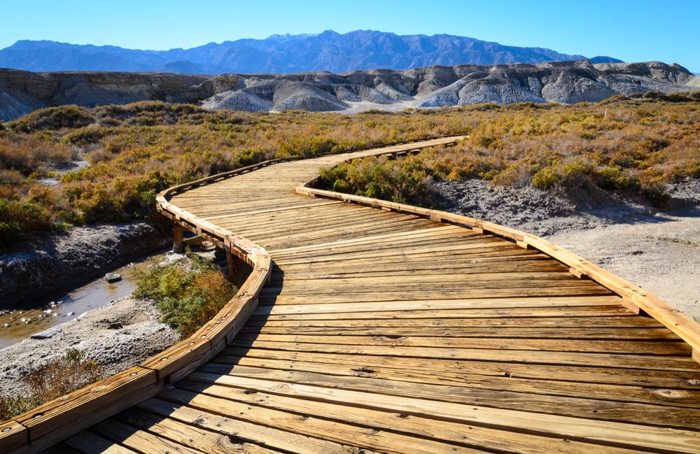
7. Death Valley National Park
💕
"Discover otherworldly landscapes and experience extreme desert beauty."
Location:
Death Valley, CA/NVHighlights:
If you're ready for jaw-dropping extremes and unforgettable desert scenery, Death Valley is a bucket-list destination. It’s a place where salt flats meet snow-capped peaks, and silence feels like part of the landscape.We Recommend This For:
Photographers, geology buffs, desert lovers, road trippers, and anyone who wants to experience one of the most unique ecosystems in the world.What we Love:
Badwater Basin’s surreal salt flats, rolling sand dunes, epic canyon drives, and the stunning contrast between desert heat and alpine heights.- Visit iconic spots like Badwater Basin (282 feet below sea level), Zabriskie Point, and the eerie landscape of the Devil’s Golf Course.
- Hike diverse trails—from the Mesquite Flat Sand Dunes to the high-elevation Telescope Peak.
- Drive through Titus Canyon’s narrow, winding roads or take in sunrise at Dante’s View for panoramic vistas.
- Discover unexpected life at spring-fed oases and see desert wildlife that thrive in this extreme setting.
Cost:
$30 per vehicle for a 7-day pass; annual passes also availableDistance from Pahrump, NV:
About 60 miles west—expect a 1 to 1.5-hour scenic drive depending on route and entry point.How to Get to Death Valley:
From Pahrump, take Bell Vista Avenue west into California, which turns into Stateline Road and eventually leads to Death Valley Junction. From there, follow signs to Furnace Creek or other park entrances.Address:
Death Valley National Park, Death Valley, CA 92328Phone: 760-786-3200, Video
Nevada State Parks for Families with Kids
8. Echo Canyon
💕
"Hike scenic trails and admire stunning rock formations."
Location:
Pioche, NVHighlights:
Want a peaceful spot with mountain views, a stocked lake, and easy trails? Echo Canyon is a year-round escape with just the right mix of water fun and quiet backcountry exploring.We Recommend This For:
Anglers, birdwatchers, campers, hikers, and families looking for a mellow, scenic getaway in Eastern Nevada.What we Love:
Calm reservoir waters for fishing and boating, abundant wildlife, and the Ash Canyon Trail’s blend of lakeside and backcountry scenery.- Fish for rainbow trout, crappie, largemouth bass, and German browns in the reservoir stocked by NDOW.
- Watch for herons, teals, and mallards—especially near dawn and dusk along the shoreline.
- Hike the 2.5-mile Ash Canyon Trail, a scenic loop into the park’s hills and high desert landscape.
- Camp at sites with tables, grills, and lake views—perfect for a weekend away from it all.
Cost:
$5 per vehicle for day use; camping and boating fees are additionalDistance from Pioche, NV:
Approximately 12 miles east—expect a 20-minute drive along Echo Dam Road.How to Get to Echo Canyon:
From Pioche, head east on Eagle Valley Road, then turn onto Echo Dam Road and follow signs to the park entrance.Address:
Echo Canyon, Pioche, NV 89043Phone: 775-962-5103
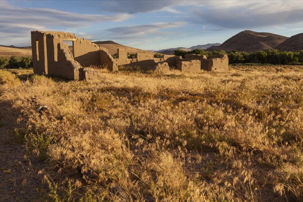
9. Fort Churchill State Historic Park
I Recommend:
"Explore historic ruins and learn about Nevada’s pioneer past."
Location:
Silver Springs, NVHighlights:
If you love frontier history and wide-open Nevada skies, Fort Churchill is a must. This ghostly adobe fort tells the story of early westward expansion and the legendary Pony Express.We Recommend This For:
History enthusiasts, families, RV campers, photographers, and anyone curious about Nevada’s military and pioneer past.What we Love:
Wandering the fort ruins at golden hour, peaceful riverside camping, and the fascinating exhibits in the visitor center.- Explore the ruins of the 1860s U.S. Army fort via a self-guided interpretive trail with historical signage throughout the site.
- Learn about the Pony Express and local Native American history at the visitor center's engaging exhibits.
- Camp at the riverside 20-site campground or picnic in scenic day-use areas beneath cottonwood trees.
- Hike trails along the Carson River and enjoy birdwatching, especially during spring and fall migrations.
Cost:
$5 per vehicle for day use; additional fees apply for campingDistance from Silver Springs, NV:
About 8 miles south—roughly a 10–15 minute drive.How to Get to Fort Churchill:
From Silver Springs, head south on US-95 ALT for about 8 miles. The park entrance is clearly marked on the east side of the road.Address:
Fort Churchill State Historic Park, 10000 US-95 ALT, Silver Springs, NV 89429Phone: 775-577-2345
10. Gold Butte National Monument
Among my top 10:
"Discover ancient petroglyphs and explore rugged desert landscapes."
Location:
Gold Butte, NVHighlights:
If you’ve ever wanted to feel like you’ve stepped onto another planet, Gold Butte is it. This remote and rugged desert treasure is perfect for adventurous souls ready to explore ancient petroglyphs, twisted canyons, and red-rock dreams.We Recommend This For:
Explorers, backcountry travelers, rock art enthusiasts, geology fans, and those seeking wide-open solitude in the Mojave Desert.What we Love:
12,000-year-old petroglyphs, the surreal red sandstone formations, ghost towns, and the peaceful silence of the remote desert landscape.- Discover thousands of petroglyphs in places like Little Finland and Newspaper Rock—some dating back over 12,000 years.
- Drive the Gold Butte Backcountry Byway to take in scenic overlooks, mining ruins, and ancient cultural sites.
- Wander among fantastical sandstone formations shaped by wind and time—perfect for hiking and photography.
- Explore on horseback or with a high-clearance 4WD vehicle to access the monument’s most remote corners.
Cost:
Free to visit; no entry or parking feesDistance from Mesquite, NV:
About 20 miles south—plan for a 1.5 to 2-hour drive due to rough roads.How to Get to Gold Butte:
From Mesquite, take Riverside Road (NV-170) south through Bunkerville, then follow Gold Butte Road into the monument. Roads are unpaved and rugged—high-clearance vehicles are strongly recommended.Address:
Gold Butte National Monument, Gold Butte, NV 89007Phone: 702-883-7777
📔 I get asked this a lot so I decided to include it:
- What are some of the famous parks in Nevada?
- Nevada is home to several stunning and unique parks, including:
- Valley of Fire State Park – Known for its striking red Aztec sandstone formations, petrified trees, and ancient petroglyphs.
- Death Valley National Park – One of the driest and hottest places on Earth, offering extreme landscapes and desert beauty.
- Lake Tahoe – A beautiful destination with crystal-clear waters, ideal for a range of water activities.
- What can I see at Valley of Fire State Park?
- Valley of Fire State Park is famous for its dramatic red sandstone formations, ancient petroglyphs, and stunning natural beauty, perfect for hiking, photography, and history enthusiasts.
- What makes Death Valley National Park unique?
- Death Valley is known for its extreme climate, with scorching temperatures and otherworldly landscapes, including salt flats, sand dunes, and canyons.
- What activities are available at Lake Tahoe?
- Lake Tahoe offers a variety of water-based activities such as boating, kayaking, paddleboarding, swimming, and even fishing, all set against a breathtaking mountainous backdrop.
Best Time to Visit Nevada State Parks
- March to May – Spring offers wildflower blooms, mild temps, and great hiking in desert and mountain parks.
- June to August – Hot in the lowlands but perfect for high-elevation parks like Cave Lake and Ward Charcoal Ovens.
- September to October – Cooler days and golden foliage—ideal for photography, camping, and trail exploration.
- November to February – Off-season with peaceful landscapes, crisp air, and great stargazing in desert parks.
- Early April – A sweet spot for colorful desert landscapes, clear skies, and fewer visitors.
Map:
🖋 How did I do?
Is the article too broad, too narrow, or just right ? Do you like the presentation of photos and text? Let me know in the comments! If you want to see more in this location, I can put it on my editorial calendar. I'm listening!
Plan Your Trip