
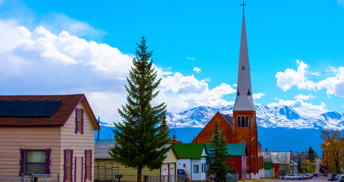
Discover Leadville, Colorado—soaring at 10,152 feet above sea level in the heart of the Rocky Mountains. Nicknamed "The Two Mile High City" and "Cloud City," Leadville is the highest incorporated city in the U.S., blending mining heritage, alpine charm, and dramatic high-elevation living.
Table of Contents
Where is Leadville?
- Location: Leadville is the county seat of Lake County, located in central Colorado amid the Rocky Mountains.
City Profile
- Nicknames: Known as The Two Mile High City and Cloud City.
- Fame: Renowned for its extremely high elevation, rich mining history, and as a gateway to Rocky Mountain adventure.
- Population: Approximately 2,700 residents.
- Size: Covers just 1.1 square miles, yet was once the second most populous city in Colorado.
- Tourism: Now a historic and recreational destination with museums, trail races, and alpine activities.
Elevation Basics
- City elevation: Leadville is located at 10,152 feet (3,094 m), making it the highest incorporated city in the United States.
- State comparison: Colorado's average elevation is 6,800 feet (2,070 m), so Leadville stands significantly higher.
- Founding year: Leadville was founded in 1877 during the Colorado Silver Boom.
- Early success: Leadville thrived as a mining hub, developing vital infrastructure like churches, hospitals, and banks.
- Economy then & now: Once fueled by silver mining, today it’s sustained by tourism and heritage sites.
- Cultural highlight: Home to the National Mining Museum and Hall of Fame.
- Sporting tradition: Hosts the grueling Leadville Trail 100 ultramarathon each year.
Must-Know Elevation Facts
- What is elevation? Elevation describes how high or low a place is compared to sea level.
- Why it matters: Elevation affects climate, temperature, oxygen levels, and vegetation patterns.
- Why so high? Leadville’s elevation is due to its position in the Rocky Mountains.
- Tree line proximity: Very near the tree line—around 11,000 feet in Colorado—where trees struggle to grow.
- Nickname meaning: Called the “Two Mile High City” because it sits nearly two miles above sea level.
- Comparison with Denver: Denver is the “Mile High City” at 5,280 feet, less than half of Leadville’s elevation.
- State city comparisons:
- Colorado Springs: 6,033 feet (1,839 m)
- Aurora: 5,472 feet (1,668 m)
- Highest point in Colorado: Mount Elbert – 14,400 feet (4,401 m), only 16 miles from Leadville.
- Lowest point in Colorado: Arikaree River – 3,317 feet (1,011 m).
Climate and Tourism
- Climate type: Leadville has an alpine subarctic climate due to its elevation and mountainous location.
- Average temperatures:
- July (warmest): Highs around 72°F (22°C), lows near 38°F (3°C).
- December (coldest): Highs around 31°F (-1°C), lows as low as 4°F (-16°C).
- Precipitation: Receives year-round rain but is known for heavy snowfall—up to 150 inches annually.
- Tourism appeal: Attracts visitors with spectacular mountain views, photography, and the allure of being the highest city in the U.S..
- Attractions: Base for hiking, skiing, and exploring the Rockies; visit the National Mining Museum.
- Altitude caution: High elevation may cause altitude sickness—stay hydrated and adjust slowly.
- Visitor tips: Prepare for thin air, cold temperatures, and bring layers and sunscreen even in summer.
Plan Your Trip