
1. Andrew Molera State Park
© rolf_52/stock.adobe.com
Location:
Big Sur, CAHighlights:
Surrounded by the magnificence of the Big Sur landscape, Andrew Molera State Park is a lightly developed haven perfect for nature lovers. It offers peaceful trails, scenic bluffs, and easy access to the beach for a full day of exploring and unwinding.We Recommend It For:
Hikers, surfers, photographers, beach walkers, and those seeking a quiet Big Sur experience without the crowds.What I Love: ♥
Miles of trails through meadows and coastal ridges, access to surfing and tide pooling beaches, and a laid-back day-use atmosphere with essential amenities.- Hike along meadows, hilltops, and coastal bluffs—trail maps are available at the Visitor’s Center.
- Surf and swim in the Pacific or explore tide pools and picnic on the shore.
- Learn from interpretive exhibits and guided tours offered by rangers on site.
- Note: This is a day-use-only park—no camping is permitted, but restrooms and drinking water are provided.
Cost:
$10 per vehicle for day useDistance from Big Sur Village:
Roughly 10 minutes north along CA-1—an easy, scenic drive.How to Get to Andrew Molera State Park:
Take California Highway 1 north from Big Sur Village. The park entrance is clearly marked on the left side of the road.Address:
Andrew Molera State Park, 5500 CA-1, Big Sur, CA 93920Phone: 831-667-1112, Map
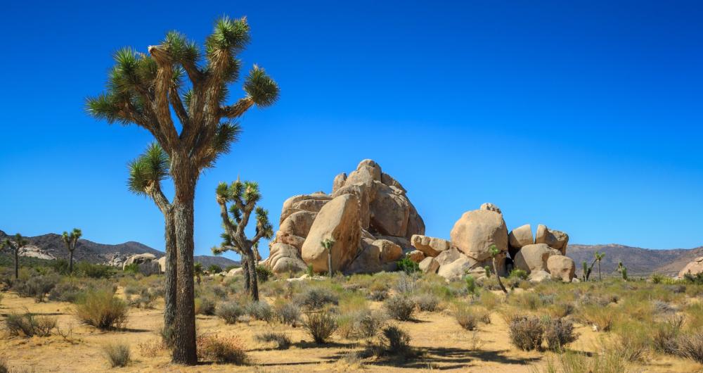
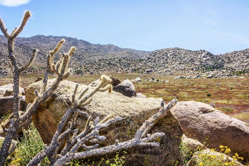
2. Anza Borrego Desert State Park
© InnaPoka/stock.adobe.com
Location:
Borrego Springs, CAHighlights:
Surrounded by rugged wind-chiseled mountains, Anza-Borrego Desert State Park invites you to experience desert beauty like nowhere else. From dramatic landscapes to stargazing and archaeological tours, this park is perfect for slow travel and deep connection with nature.We Recommend It For:
Backpackers, desert explorers, RV travelers, families, hikers, and those interested in archaeology and geology.What I Love: ♥
The raw desert terrain, scenic drives and trails, behind-the-scenes archaeological tours, and an impressive visitor center to get you started.- Begin at the Visitor’s Center to watch the 15-minute orientation film and explore educational exhibits about the region.
- Camp for a few nights—choose from full-service campgrounds for RVs or primitive backcountry sites for a more rugged experience.
- Hike through dramatic desert canyons with trails for all experience levels—from easy family walks to intense, expert routes.
- Join seasonal archaeological tours and events—check the official website for schedules and availability.
Cost:
$10 per vehicle for day use; camping fees varyDistance from Borrego Springs:
Located directly in Borrego Springs—just minutes from town center.How to Get to Anza-Borrego Desert State Park:
From Borrego Springs, take Palm Canyon Drive directly into the park. The main visitor center and campground entrances are clearly signed along the route.Address:
Anza-Borrego Desert State Park, 20 Palm Canyon Dr, Borrego Springs, CA 92004Phone: 760-767-4205, Map
3. Bothe-Napa Valley State Park
© Matthew Benoit/stock.adobe.com
Location:
Calistoga, CAHighlights:
Nestled in the heart of Napa Valley, Bothe-Napa Valley State Park blends scenic outdoor adventures with wine country charm. Whether you’re hiking, camping, or relaxing in a yurt, it’s a perfect escape for nature lovers of all ages.We Recommend It For:
Hikers, families, campers, wine country travelers, and those looking to unwind in a natural setting near vineyards and small towns.What I Love: ♥
Shaded trails, summertime swimming, educational programs, and the chance to sleep under redwoods in a yurt, cabin, or tent.- Hike scenic trails that wind through redwoods and forested canyons, with guided nature walks available throughout the year.
- Stay overnight in tent and RV campsites—or opt for a cozy yurt or rustic cabin for added comfort.
- Swim in the seasonal outdoor pool, picnic under towering trees, and let the kids explore the Junior Ranger program.
- Visit the Native American Garden Trail and Visitor’s Center for educational insights into the region’s cultural and ecological history.
Cost:
$10 per vehicle for day use; overnight fees vary by accommodation typeDistance from Calistoga:
Just 10 minutes south of downtown Calistoga—an easy drive for a peaceful getaway.How to Get to Bothe-Napa Valley State Park:
Take CA-29/St. Helena Hwy south from Calistoga for about 4 miles. The park entrance is clearly marked and located on the west side of the road.Address:
Bothe-Napa Valley State Park, 3801 St Helena Hwy, Calistoga, CA 94515Phone: 707-942-4575, Map
Romantic California Parks
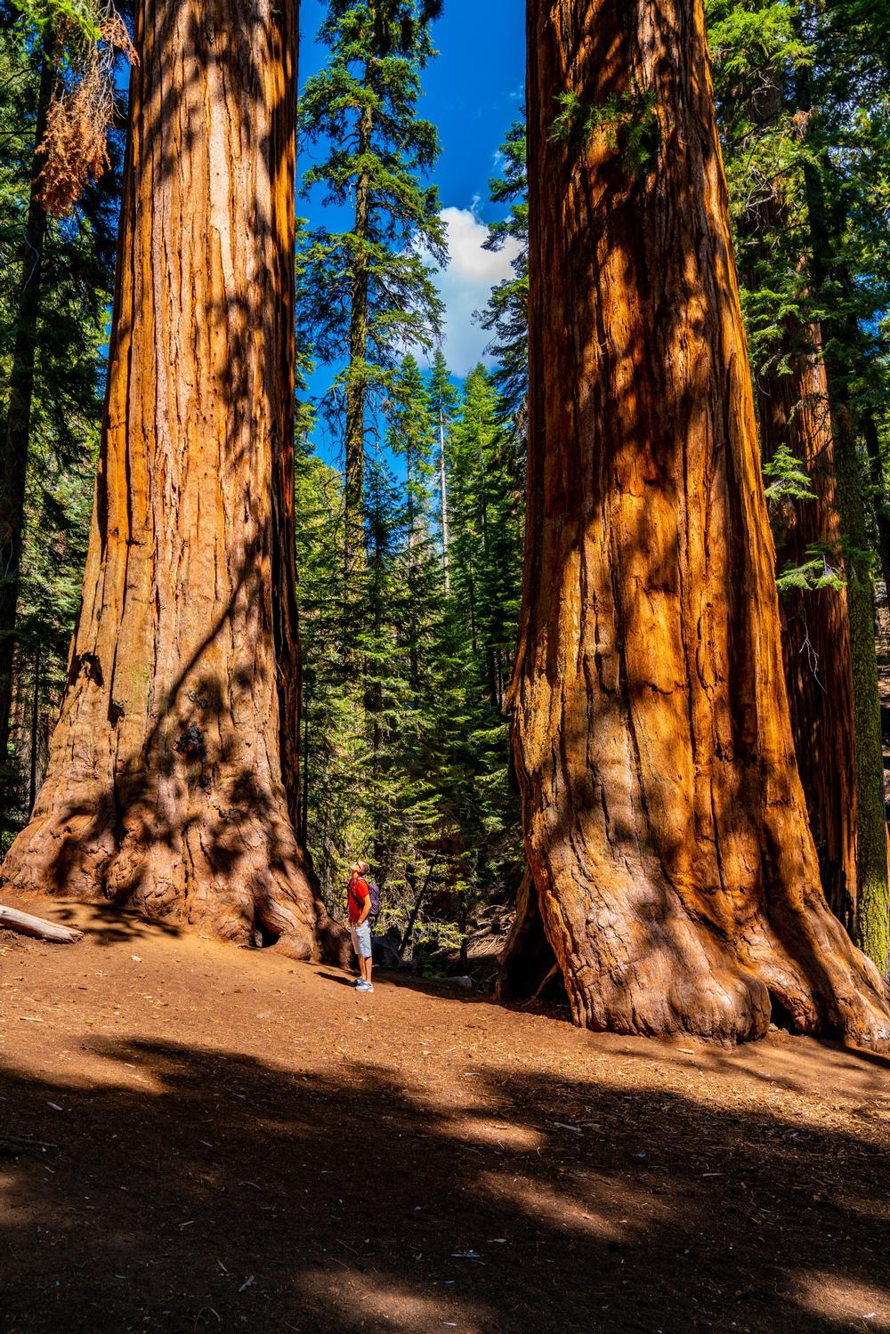
4. Calaveras Big Trees State Park
© ingusk/stock.adobe.com
Location:
Arnold, CAHighlights:
Home to the magnificent North Grove of giant sequoias, Calaveras Big Trees State Park is a must-see for anyone who loves forests, fresh air, and jaw-dropping natural wonders. Whether you're camping or just hiking for the day, these towering trees are unforgettable.We Recommend It For:
Hikers, campers, nature lovers, families, and anyone seeking a peaceful forest getaway with incredible scenery.What I Love: ♥
The towering groves of ancient sequoias, scenic hiking trails through multiple groves, and the family-friendly mix of biking, fishing, and guided weekend hikes.- Wander among some of California’s most iconic trees in the North Grove, South Grove, and Bradley Grove areas.
- Camp under the stars at one of two large campgrounds with easy access to trailheads and park amenities.
- Join Saturday guided hikes or pick up trail maps and park tips at the Visitor’s Center.
- Bike and Fish in designated areas—this park offers more than just walking trails!
Cost:
$10 per vehicle for day use; camping fees vary by site and seasonDistance from Arnold:
About 5 minutes northeast of downtown Arnold—an easy forest escape right nearby.How to Get to Calaveras Big Trees State Park:
Head east on CA-4 from Arnold for roughly 4 miles. The park entrance is clearly marked and just off the highway.Address:
Calaveras Big Trees State Park, 1170 CA-4, Arnold, CA 95223Phone: 209-795-2334
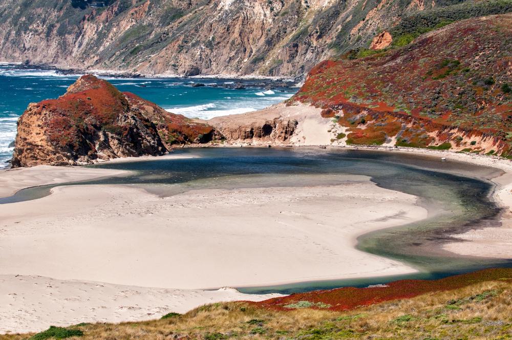
5. Coast Dairies State Park
© RobertU/stock.adobe.com
Location:
Santa Cruz, CAHighlights:
Once threatened by development, Coast Dairies State Park is now a preserved seven-mile stretch of wild, rugged coastline that’s yours to explore. With remote beaches, crashing surf, and coastal trails, it’s a true California treasure for day-use adventurers.We Recommend It For:
Hikers, surfers, beachcombers, nature lovers, and anyone seeking an unspoiled coastal escape away from the crowds.What I Love: ♥
The raw beauty of its seven beaches, the long coastal trail connecting them, and the park’s preservation story that kept this land public and wild.- Hike the seven-mile coastal trail that links the park’s secluded beaches—each with its own unique character.
- Explore tide pools, collect beach treasures, or watch the waves crash along the rugged cliffs and shoreline.
- Surf or windsurf in designated beach zones—these uncrowded waters offer a rare kind of freedom.
- Note: This is a day-use-only park—no camping is permitted.
Cost:
Free to enterDistance from Santa Cruz:
About 15 minutes north of downtown Santa Cruz along scenic Highway 1.How to Get to Coast Dairies State Park:
Head north from Santa Cruz on Cabrillo Highway (CA-1). Look for access points and signage along the coast between Santa Cruz and Davenport.6. Cuyamaca Rancho State Park
© Autumn Sky/stock.adobe.com
Location:
Julian, CAHighlights:
Located east of San Diego, Cuyamaca Rancho State Park is a mountain oasis of forests, creeks, and meadows. Whether you're hiking, camping, or horseback riding, it's an ideal place to recharge in the fresh air and natural beauty of Southern California.We Recommend It For:
Campers, hikers, equestrians, nature lovers, and anyone looking for a quiet forest escape near San Diego.What I Love: ♥
Over 100 miles of trails to explore by foot, bike, or horseback, plus two great campgrounds and scenic picnic areas for day visitors.- Hike or Ride through 100+ miles of trails that wind through pine forests, meadows, and rippling creeks.
- Camp at either Paso Picacho or Green Valley Campgrounds, both equipped with picnic tables, fire rings, and clean restroom and shower facilities.
- Go rustic at one of two primitive hike-in or ride-in campsites designed for backcountry adventurers and equestrians.
- Relax at shaded day-use areas with parking, restrooms, and plenty of room to picnic and recharge.
Cost:
$10 per vehicle for day use; camping fees vary by site and seasonDistance from Julian:
About 15 minutes south of downtown Julian via Highway 79.How to Get to Cuyamaca Rancho State Park:
From Julian, take Highway 79 south for approximately 10 miles. The park entrance and campgrounds are well marked along the route.Address:
Cuyamaca Rancho State Park, 13652 Highway 79, Julian, CA 92036Phone: 760-765-3023
Family-Friendly California Parks
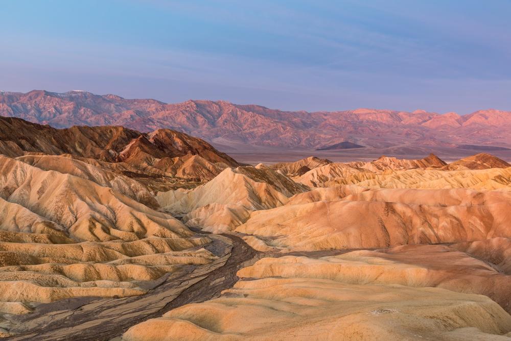
7. Death Valley National Park
© Alexey/stock.adobe.com
Location:
Death Valley, CAHighlights:
When you arrive at Death Valley National Park, you’re stepping into the driest, lowest, and hottest national park in the U.S. From salt flats below sea level to distant snow-capped peaks, this wild and extreme landscape offers unforgettable views and experiences.We Recommend It For:
Adventurers, landscape photographers, hikers, campers, road trippers, and anyone drawn to remote, dramatic environments.What I Love: ♥
The dramatic contrast between blazing desert and snowy mountains, a rare desert bloom after rain, and the sheer size of the park offering endless places to explore.- Drive scenic routes to iconic sites like Badwater Basin, Zabriskie Point, and Dante’s View.
- Hike on trails that range from short boardwalk strolls to rugged backcountry adventures and canyon climbs.
- Camp in your style—whether that’s a luxury lodge, a fully serviced RV campground, or a primitive tent site under the stars.
- Explore by mountain bike or go birdwatching in surprising desert oases and high-altitude habitats.
Cost:
$30 per vehicle for a 7-day pass; annual America the Beautiful passes acceptedDistance from Furnace Creek (main visitor hub):
The park entrance is just minutes away—start your adventure right at the center.How to Get to Death Valley National Park:
From Las Vegas, take NV-160 west to Pahrump, then follow signs to CA-190 into the park. From California, access the park from US-395 via Lone Pine or Ridgecrest.Address:
Death Valley National Park, Death Valley, CA 92328Phone: 760-786-3200
8. Del Norte Coast Redwoods State Park
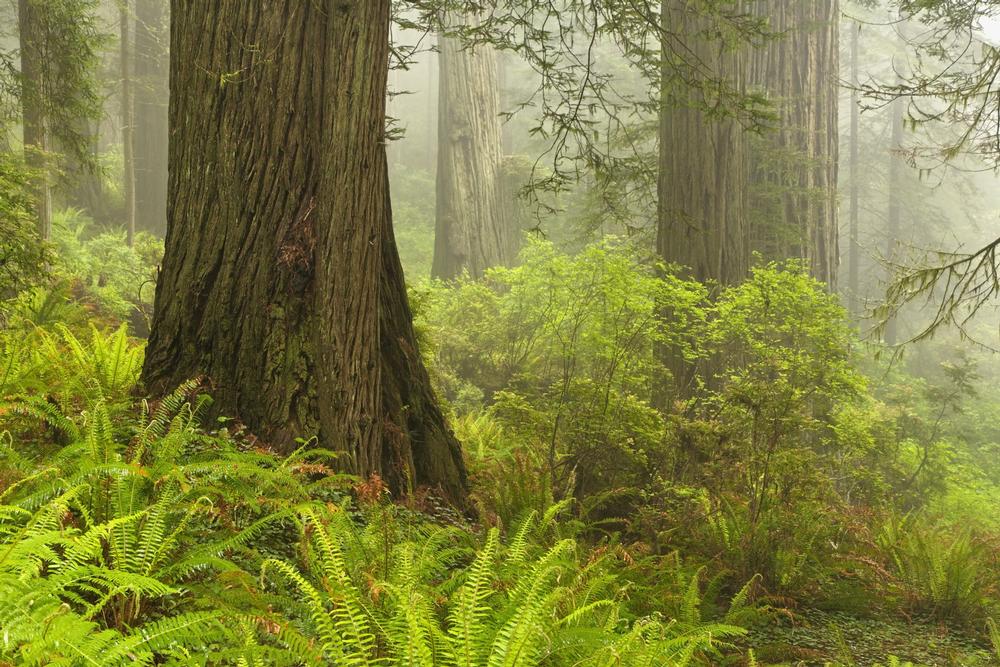
© cucumber images/stock.adobe.com
Location:
Crescent City, CAHighlights:
Located just south of Crescent City, Del Norte Coast Redwoods State Park protects a breathtaking stretch of redwood-lined coastline. Towering trees, dramatic bluffs, and wild beaches make this a dream destination for hikers, bikers, and nature lovers.We Recommend It For:
Hikers, cyclists, redwood seekers, coastal explorers, photographers, and those craving an off-the-beaten-path outdoor experience.What I Love: ♥
The mix of ancient redwood forest and raw Pacific coast, scenic drives for non-hikers, and trails like Damnation Creek and the Coastal Trail that offer serious wow-factor.- Hike the rugged Damnation Creek Trail—a steep, rewarding 4-mile trek from forest to beach and back.
- Wander the Coastal Trail through old-growth redwoods and along rocky bluffs with ocean views.
- Enjoy beach walking, tide-pooling, and fishing—but note that swimming is not permitted.
- Camp at Mill Creek Campground during the summer months for an immersive forest stay under the redwoods.
- Drive one of several scenic coastal routes if you're short on time or prefer to enjoy the views from the road.
Cost:
$8 per vehicle for day use; camping fees varyDistance from Crescent City:
About 10 minutes south via Highway 101How to Get to Del Norte Coast Redwoods State Park:
Take US-101 south from Crescent City. The park entrance and trailheads are well signed and easy to access along the highway.Address:
Del Norte Coast Redwoods State Park, 1111 2nd Street, Crescent City, CA 95531Phone: 707-465-7335
9. Donner Memorial State Park
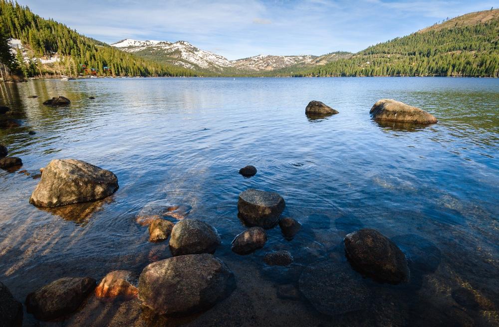
© Zack Frank/stock.adobe.com
Location:
Truckee, CAHighlights:
Nestled in the heart of the Sierra Nevada, Donner Memorial State Park honors the brave pioneers who crossed the mountains in the 1800s. Today, it’s a scenic year-round destination with trails, lakeside views, and a powerful historic story to explore.We Recommend It For:
History buffs, campers, paddlers, hikers, snowshoers, and families looking for a blend of outdoor fun and learning.What I Love: ♥
Seasonal recreation on Donner Lake, cross-country trails in winter, and the engaging exhibits at the Emigrant Trail Museum and Visitor’s Center.- Play outdoors all year—enjoy boating, fishing, hiking, and swimming in summer, and snowshoeing or cross-country skiing in winter.
- Learn about the region’s pioneer and geological history at the Visitor’s Center, open year-round.
- Camp among towering pines near the lake—sites can be reserved up to six months in advance.
- Reflect at the Donner Party Monument and walk in the footsteps of early California emigrants.
Cost:
$10 per vehicle for day use; camping fees vary by seasonDistance from Truckee:
Just 5 minutes west of downtown Truckee along Donner Pass RoadHow to Get to Donner Memorial State Park:
From Truckee, take Donner Pass Road west. The park entrance is clearly marked near the eastern edge of Donner Lake.Address:
Donner Memorial State Park, 12593 Donner Pass Rd, Truckee, CA 96161Phone: 530-583-7892
10. Garrapata State Park
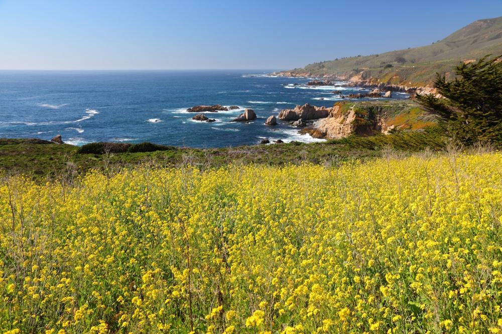
© Tupungato/stock.adobe.com
Location:
Carmel-By-The-Sea, CAHighlights:
Just 18 miles from Big Sur, Garrapata State Park is one of those hidden coastal gems that’s perfect for a scenic stop—or a full day of outdoor adventure. With dramatic cliffs, two miles of beach, and marine life galore, it's a dream for hikers, beachgoers, and wildlife lovers.We Recommend It For:
Coastal hikers, photographers, surfers, snorkelers, and anyone cruising Highway 1 with time to explore.What I Love: ♥
Sweeping ocean views, beach access for swimming and water sports, and the chance to spot seals, sea lions, otters—or even a migrating gray whale.- Hike coastal trails with jaw-dropping views of cliffs, wildflowers, and crashing waves.
- Swim, surf, snorkel, or dive along the two-mile stretch of sandy beach—just be mindful of changing ocean conditions.
- Watch for sea mammals year-round and gray whales during their migration season.
- Note: This is a day-use-only park—there are no campgrounds or overnight accommodations.
Cost:
Free to enter; roadside parking available at trailheadsDistance from Big Sur:
Approximately 18 miles north via Highway 1—perfect for a scenic detour or stopover.How to Get to Garrapata State Park:
Drive along CA-1 north from Big Sur or south from Carmel. Trailheads are unmarked but start at various pullouts between mile markers 63 and 67.Address:
Garrapata State Park, CA-1, Carmel-By-The-Sea, CA 93923Phone: 831-624-4909
Plan Your Trip