
Discover the soaring elevation of Mt. Whitney—the highest point in California, the entire contiguous United States, and the majestic Sierra Nevada range, towering at over 14,500 feet in dramatic contrast to the valleys and deserts below.
Table of Contents
- Where is Mt. Whitney?
- Mountain Profile
- Elevation Basics
- Must-Know Elevation Facts
- Climbing and Altitude
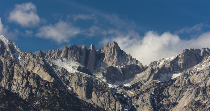
Where is Mt. Whitney?
- Location: Mt. Whitney straddles Inyo and Tulare counties in central California, within the Sierra Nevada mountain range.
- National Parks: Its western slope lies in Sequoia National Park, and the eastern slope falls within Inyo National Forest.
Mountain Profile
- Elevation: Stands at an official height of 14,505 feet (4,421 m) above sea level.
- Prominence: One of North America’s most prominent peaks with 10,075 feet (3,071 m) of prominence.
- Visual impact: Known for its jagged ridges and sweeping visibility across the Sierra backcountry.
- Fame: Most elevated peak in the lower 48 states, attracting climbers, hikers, and mountaineers from all over the world.
Elevation Basics
- First ascent: Successfully summited on August 18, 1873 by locals Charles Begole, John Lucas, and A.H. Johnson.
- Historical elevation: Originally recorded as 14,494 feet (4,418 m), still noted on summit plaques.
- Updated measurement: Newer, more accurate GPS-based measurements updated the elevation to 14,505 feet (4,421 m).
- California context: California's mean elevation is 2,900 feet (880 m), with Mt. Whitney as its highest point and Badwater Basin in Death Valley—279 feet (85 m) below sea level—as the lowest.
- National comparison: While Mt. Whitney is the highest in the lower 48 states, Denali in Alaska stands taller at 20,310 feet (6,190 m).
Must-Know Elevation Facts
- Most popular route: The Mount Whitney Trail, starting at Whitney Portal near Lone Pine.
- Trailhead elevation: 8,360 feet (2,550 m).
- Trail length and gain: Roughly 22 miles (35 km) round-trip with an elevation gain of around 6,100 feet (1,900 m).
- Key waypoints: Includes Outpost Camp – 10,365 feet (3,159 m), Trail Camp – 12,000 feet (3,700 m), and Trail Crest – 13,645 feet (4,159 m), the highest trail pass in the U.S.
Climbing and Altitude
- Climbing duration: Most climbers complete the ascent over 2 days, though it remains strenuous and requires preparation.
- Changes over time: From early expeditions to today’s guided climbs, modern equipment and planning make the trek more accessible.
- Elevation vs. prominence: Elevation measures height above sea level; prominence is the vertical distance between the summit and surrounding terrain.
- Altitude sickness risk: Symptoms can start at 8,000 feet (2,438 m) and include nausea, headache, and breathlessness due to thinner air.
- Climber tips: Acclimate before your climb, stay hydrated, and pack warm layers—the summit can be icy even in summer.
Plan Your Trip