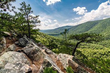
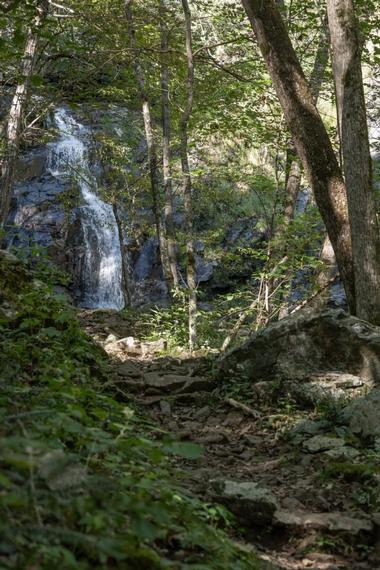
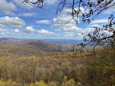
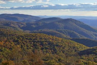
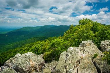
Two major mountain chains make up the geography of Virginia – the Blue Ridge Mountains and the Allegheny Mountains, each with their own share of wonderful hiking and climbing destinations. The most popular and arguably most beautiful Virginia mountains are part of Shenandoah National Park. What makes the Virginia's mountains so special is that they are richly forested, so the hikes are shady and pleasant, the trails are surrounded by wildflowers, and occasional rocky outcrops provide lovely views of the surrounding areas. They are also full of wildlife. There are easy, pleasant mountains perfect for a day hike, while those that are more distant and more rugged provide a solitary experience.


Old Rag Mountain

Old Rag Mountain

© Courtesy of Olga Yudina - Fotolia.com

Old Rag is a 3,268-foot-tall exposed granite mass located in the Shenandoah National Park, east of the Blue Ridge. One of the first mountains that outdoorsy Virginians tackle, Old Rag will make you hike about 3 miles to reach the summit if you take the shortest route, gaining 2,200-3,000 feet in elevation. Most of the commonly used standard route crosses open rock, making the hike an above-timberline experience, rare in the Southeast. Some Class 3 scrambling is involved, making hiking Old Rag a real adventure for beginner hikers who have never experienced real alpine mountains. The trail can get crowded since it is only 2 hours from Washington, D.C. Browse our Romantic Weekend Getaways in Virginia guide for more ideas.


Mount Rogers

Mount Rogers

© Courtesy of lumikk555 - Fotolia.com

At 5,729 feet, Mount Rogers is the most famous and the highest peak in Virginia. There are no roads leading to the summit, making it secluded and isolated. There are two major hiking trails up the mountain. The shortest, and for that reason the most popular, route is via Massie Gap in Grayson Highlands or the Elk Garden Trailhead. The Massie Gap is an 8-mile round trip, and the Elk Garden is little longer at 9 miles. The Massie Gap Trail is the most scenic summit approach and by far the most popular way to get up Mount Rogers. Mount Rogers is the summit of the Mount Rogers National Recreational Area, which was established to protect the natural landscape. The mountain is one of the last remaining homes to Southern Appalachian spruce-fir forests, with the rare Fraser fir, which normally grows above 5,500 feet. While beautiful, these massive trees obstruct any view you might have hoped for from the summit of Mount Rogers. However, the trail has other delights, such as rhododendron thickets, which bloom vividly during the months of May and June, and a chance to see some wild ponies.

More ideas: Places to Visit in Virginia


Pignut Mountain, Virginia

Pignut Mountain, Virginia

© Courtesy of William - Fotolia.com

Pignut Mountain is located in Shenandoah National Park, between Thornton Gap and Front Royal, Virginia. The 2,531-foot-tall mountain is part of the Blue Ridge. There is no trail going all the way to the Pignut summit. You have to take the Keyser Run Fire Road, which will bring you to a saddle about 0.6 miles from the summit. This saddle is the site of the old Bolen Cemetery, a resting place of some of the hardy people who lived in this rugged, isolated area before it became Shenandoah National Park. You will find the trailhead at an elevation of almost 1,200 feet. As you hike along the Keyser Run Fire Road for about 1.2 miles until it meets the Hull School Road Trail, you will gain about 700 feet in elevation. To reach the summit, this hike is about 3.6 miles, and the total elevation gain is about 1,330 feet.

More ideas: Things to Do in Virginia


High Knob - Stone Mountain

High Knob - Stone Mountain

© Courtesy of avvgeo - Fotolia.com

At 4,233 feet, High Knob is Wise County’s tallest mountain. It is located at the intersection of Powel and Stone Mountains, parallel to Powell River Valley, above Big Stone Gap and Pennington in Virginia. The Nature Conservancy considers High Knob an important area of natural diversity, creating a dispute with logging interests. Once you reach the summit, you can see all the way to Kentucky, Tennessee, and even West Virginia. Camp Rock and one of the most popular overlooks are located 1.5 miles from the summit. High Knob is known as the location of the Omega Cave System, with the deepest cave this side of the Mississippi at 1,263 feet. (website link)

More ideas: Lakes in Virginia


Apple Orchard Mountain

Apple Orchard Mountain

© Courtesy of olehslepchenko - Fotolia.com

Don’t expect to find any apple orchards on Apple Orchard Mountain. This 4,225-foot mountain is covered with forests of northern red oaks, which wind and time have severely pruned over the years to resemble an apple orchard. The Appalachian Trail and the Blue Ridge Parkway will take you almost to the summit. The top of the mountain is open and is dominated by a naval radar station, which is off limits, although it presents a great temptation because of the views it awards. For those hiking the Appalachian Trail, the Apple Orchard Mountain summit is the tallest peak for 1,000 miles if heading north or 300 miles if heading south. The slopes of the mountain make for great hiking, as they are densely covered with verdant vegetation and full of wildlife. It is not rare to spot black bears and whitetail deer. Close to the summit, you will pass an impressive, very beautiful waterfall.

More ideas: Things to Do in the Chesapeake Bay


Middle Mountain, Virginia

Middle Mountain, Virginia

© Courtesy of Victoria Lipov - Fotolia.com

At 3,187 feet, located in Douthat State Park, Middle Mountain is just about in the middle between mountains and high hills. It is a fairly typical Blue Ridge peak, with a long, steep ridge separated from other summits by low gaps. There are no clear, open summits on Middle Mountain, only a few rocky outcrops breaking the dense cover of mostly hardwood forests. There are very few evergreens on the mountain slopes, mostly isolated in the humid areas near the streams. Most springs, streams, and waterfalls in the area disappear during late summer and fall. To reach the summit, you will have to use a number of interconnecting trails, which make a 13-mile-long loop. The trailhead is at White Oak Campground.

More ideas: Virginia State Parks


Virginia Mountains: Rockytop

Virginia Mountains: Rockytop

© Courtesy of William - Fotolia.com

At 2,856 feet, Rockytop is one of the largest peaks in the South District of the Shenandoah National Park and part of the Big Run watershed. South District has few trails, so it is much less used than the other of the park’s districts. The trails running through the Big Run pass through gorgeous landscapes of high cliffs, talus slopes, clear trout streams, and sandstone outcrops. This is wild area, with common sightings of bears. The high ridge of Rockytop dominates the view as seen from the Big Run Overlook, from Skyline Drive.

It forms one of the walls of Big Run Canyon. The trail through Rockytop runs along the ridgeline, crossing a number of talus slopes, the main attractions of Rockytop since they provide excellent views of parts of the park. The talus slopes contain interesting specimens of fossilized wormholes that are 500 million years old.

More ideas: Beaches Near DC


Hazel Mountain

Hazel Mountain

© Courtesy of Vladimir Grablev - Fotolia.com

Hazel Mountain rises 2,878 feet north of Nicholson Hollow proper, between Short Mountains and Catlett. It is not distinguished in any way and has no trail to the top and no unrestricted views from the summit. On the summit, there are only a few small glades and no signs of people ever passing through. And that solitude is the best reason to go up Hazel Mountain, exploring the true wilderness only 1.5 hours from the main metropolitan centers. However, this is not a mountain for the uninitiated and inexperienced. There are two possible routes to the top, both requiring off-trail scrambling and bushwhacking through a lot of thorny undergrowth. For that reason, it is better to hike in the winter when the bushes are less dense. From Skyline Drive, you can take the 7.5-mile White Rocks-Hazel Mountain Loop, and from outside the park, the 6-mile Hazel River-Sam's Ridge Loop. Watch out for snakes and poison ivy.

More ideas: Things to Do in Northern Virginia


Oventop Mountain, Virginia

Oventop Mountain, Virginia

© Courtesy of AlenKadr - Fotolia.com

Oventop Mountain is a 2,468-foot mountain in Blue Ridge mountain range, a lovely forested mountain that gets more interesting as you get closer to the summit. There are some nice outcrops that are practically as high as the real summit with lovely views, a few clear, and one rocky outcrop that requires some serious scrambling to get to the top. There is an old trail that runs along the mountain ridges, connecting all three summits, and while not maintained, you will find it along the way in places. If you like solitude and enjoy some bushwhacking, you will love Oventop Mountain. To reach the main summit, you will hike 1.8 miles and gain 1,100 feet in elevation. There are no campgrounds, but back-country camping is allowed with a permit.

More ideas: Virginia Beaches


The Pinnacle

The Pinnacle

© Courtesy of sirfujiyama - Fotolia.com

At 3,730 feet, the Pinnacle is the tallest mountain in Rappahannock County. It is located in Shenandoah National Park and its summit is just off the Appalachian Trail. The trailhead is accessible from Skyline Drive. The trail along the mountain contains a number of large boulders, perfect for rock climbing. Once at the top, there are several spots with excellent views of the Shenandoah Valley and all the surrounding mountains. If you want to extend your hike, you can easily go from the Pinnacle to the more popular neighbor, Marys Rock. There are two main routes up the Pinnacle: from Skyline Drive, take a 3-mile Meadow Spring Trail or a 1.6-mile easy trail from Jewel Hollow Overlook.

More ideas: Day Trips from DC


Salt Pond Mountain

Salt Pond Mountain

© Anchasa/stock.adobe.com

At 4,054 feet, Salt Pond Mountain is a large mountain that straddles the high country in the Mountain Lake Wilderness Area close to the border between Virginia and West Virginia. The "Salt Pond" that gave the mountain its name is now known as Mountain Lake, located just outside the Mountain Lake Wilderness. The Appalachian Trail passes straight through the mountain and through the Mountain Lake Wilderness, bringing a large number of visitors. The forests on Salt Pond Mountain are more typical of northerly mountains, with hardwoods, red spruce, and yellow birch. Most of old-growth hemlock trees have been destroyed by aphids. In winter, Salt Pond Mountain is a popular with the cross-country ski crowds.

More ideas: Things to Do in Virginia Beach


Bird Knob

Bird Knob

© karelian/stock.adobe.com

Bird Knob is a 2,684-foot mountain in the George Washington National Forest. New Market Gap, at about 1,800 feet, divides the Massanutten Range and connects New Market with Luray. Bird Knob is located just a few miles from New Market Gap. After a steep section at the start, the hike to Bird Knob is a pleasant walk along the ridge, with some nice views from a few rock outcrops, before a short bushwhack and scramble to the top. If you want, you can also visit a nearby spring-fed pond. You can climb Bird Knob in any season except probably during the fall hunting season. Winter is best, since there are no bugs and there is less undergrowth. Camping is free anywhere in the George Washington National Forest.

More ideas: Things to Do in Middleburg


Calf Mountain

Calf Mountain

© ellyvandellen/stock.adobe.com

Calf Mountain is a 2,974-foot-tall mountain on the edge of Shenandoah National Park. It does not offer any exciting rock scrambling or beautiful scenery, but once you reach its two lower summits, you will get breathtaking views of the Piedmont, Shenandoah Valley, and many steep ridges of the Appalachians. The highest summit does not have an unobstructed view, and the Appalachian Trail goes straight over it. A short distance from the summit is the famous Calf Mountain Shelter, a stone shelter used by backpackers when in need. It has a fire pit, an important point since fires are not allowed in the park. Along the trail, there are small trees and thick brush, providing shade but obstructing the view.

More ideas: Weekend Getaways from DC


Cat Knob

Cat Knob

© Jacob Lund/stock.adobe.com

Cat Knob is a 3,680-foot-high mountain summit in Shenandoah National Park, south of Big Meadows. The summit can be reached with a 4-mile hike once you get off the Skyline Drive. The trail to the summit runs along the side of a mountain, offering beautiful views all the way. This is one of the hikes offering the highest elevation gain, so it presents a nice challenge. It is possible to climb it all year around. While the colors are spectacular in the fall, the undergrowth is thick and impedes progress. There is also poison ivy as well as snakes. Winter is great time to hike if there is not too much snow.

More ideas: Things to Do in Smithfield


Buck Ridge

Buck Ridge

© leszekglasner/stock.adobe.com

Buck Ridge, at an elevation of 2,655 feet, is a ridge just off the main crest of the Blue Ridge in Shenandoah National Park, near Marys Rock. It runs in a southwesterly direction for about 3 miles until the Skyline Drive, where it keeps climbing before joining the crest of the range south of Marys Rock. Don’t expect any views, it is too forested, but enjoy the streams, the ancient trees, the wildflowers, and the serenity. The stream running through Buck Hollow is surrounded with mossy rocks, lively small cascades, and clear pools, as you would expect in the southern Appalachians. Hiking Buck Ridge is best from May to early June, when you will be hiking through a sea of wildflowers.

More ideas: Things to Do in Williamsburg


Massanutten Peak

Massanutten Peak

© James/stock.adobe.com

Massanutten Peak is a 2,922-foot-high peak at the southern end of the Massanutten Mountains, near the city of Harrisonburg. The area is best known for the great skiing, snowtubing, and snowboarding offered by the Massanutten Resort, but the resort guests also enjoy hiking in the surrounding mountains. Massanutten Peak is privately owned, one of the few in the Massanutten Mountains. The hike offers great views of the Blue Ridge Mountains in Shenandoah National Park as well as Kaylor, Hartman, and Lairds Knob. The trail is located on private property, but it is open to people not staying at the resort. The trail is closed for hiking during the hunting season, from early November to late February.

More ideas: Beaches Near Williamsburg


Little Walker Mountain, Virginia

Little Walker Mountain, Virginia

© Atlas/stock.adobe.com

Little Walker Mountain is a 3,340-foot-high ridge that runs northeast/southwest for about 20 miles, creating a typical Blue Ridge profile. The ridge rises about 1,000 feet higher than its base on both ends. The entire ridge is part of the Jefferson National Forest and is covered with southern Appalachian hardwood forest with chestnut oak, northern white oak, sugar maple, some white pine groves, and a few Carolina hemlocks. The Seven Sisters Trail runs for about 5 miles along the Little Walker Mountain’s highest ridges. Not the easiest of hikes, but the trail is surrounded by wildflowers. It's a well-marked and rarely used trail, so you can enjoy your solitude.

More ideas: Things to Do in Charlottesville


Jones Mountain

Jones Mountain

© kellyvandellen/stock.adobe.com

What makes Shenandoah National Park stand out from other great parks in the country is that it is so close to major metropolitan centers, so lot of people can enjoy hiking through the wilderness. But, it also means crowds. Those who are looking for solitude pick places such as 3,482-foot-tall Jones Mountain and its exposed outcrop of Bear Church Rock. Most hikers you will meet head to or from the Jones Mountain Cabin, managed by the Potomac Appalachian Trail Club. The trail up the mountain is relaxed and quiet, surrounded by wildflowers and colorful lichens. The park is open all year round except during the hunting season, and the Skyline Drive closes after heavy snow or ice storms. The closest campground is Big Meadows.

More ideas: Things to Do in Norfolk


Walker Mountain

Walker Mountain

© bouybin/stock.adobe.com

Walker Mountain, also called Big Walker Mountain, is a 3,894-foot-tall, fairly typical Blue Ridge peak in the southwestern Virginia. The peaks are covered in dense hardwood forests with northern white oaks, bitternut hickory, shagbark hickory, sugar maples, and many other tree species. Hiking through these forests is a true delight for people appreciating the plant variety. Walker Mountain is famous for its private lookout tower located on VA 52, a part of the Big Walker National Scenic Byway. The tower is 100 feet tall and accessible for $5. Just past the tower is the Walker Mountain Trail, which runs along the highest portion of the ridge. The trail goes up and down, crossing a few shallow gaps and saddles between the peaks. You can also go off-trail for short bushwhacks, to head to the higher peaks. The trail is not heavily used and is well marked and maintained. From the Appalachian Trail to the high point close to the Big Walker Lookout, you will gain about 1,400 feet in elevation.

More ideas: Things to Do in Yorktown


The Peak

The Peak

© fotobieshutterb/stock.adobe.com

Only 2,925 feet high, the Peak is not the tallest or the most popular since it has no hiking trails going up. What makes it special is the fact that it is detached from the Blue Ridge’s main crest and separated from Mount Marshal by the Thoroughfare Gap. It drops steeply to farmlands far below, making it appear massive and forbidding. It is also fairly wild, with not much of a human presence. If you do decide to go up the Peak, go in the spring when it is covered with wildflowers and lush trees. Fall is also lovely, with a rainbow of leaf colors, but be prepared for some bushwhacking, there is a lot of thick thorny undergrowth. The best approach to the Peak is from small rural roads on the east side of the park and not from the Skyline Drive. This will also ensure wonderful solitary experience.

More ideas: Things to Do in Culpeper


Buffalo Mountain

Buffalo Mountain

© mzglass96/stock.adobe.com

With an elevation of 3,971 feet, Buffalo Mountain is protected by the Buffalo Mountain Natural Area Preserve. It stands alone on the high plateau, rising more than 1,000 feet above the surrounding area. Its peak consists of wide exposed rock that provides a home to an unusual plant community, rare for the area. There is no real tree line, as is common in the South, although such bare mountain peaks are generally not that common. The trail to the top is only a mile long, but you will gain almost 700 feet in elevation as it goes up and up. However, the walk is pleasant, through a lovely hardwood forest with a few evergreens, and the views from the top of the Blue Ridge region are fantastic. The summit has two sharp peaks that look like horns, which gave it its name.

More ideas: Places to visit in West Virginia


Rocky Knob

Rocky Knob

© Sean Board/stock.adobe.com

Rocky Knob is a 3,572-foot-high ridge running along the Virginia part of the Blue Ridge Parkway for a few miles. Rocky Knob is not really rocky and not open at the top as you would expect, as so many other Blue Ridge peaks are. However, since there are few openings among the trees, you will be rewarded with a nice view along the way. One of the most beautiful is the view of Rock Castle Gorge, 1,800 feet below. There is a trail through the gorge that used to be a wagon road. Not a very challenging climb, Rocky Knob is a peak to bag as you are driving along the Blue Ridge Parkway, which runs between Shenandoah National Park and Great Smoky Mountains National Park in North Carolina. There are few trails going up to the summit and the longest way is only about a mile, with an elevation gain of about 500 feet.

More ideas: Things to Do in Alexandria


Trayfoot Mountain, Virginia

Trayfoot Mountain, Virginia

© Trayfoot Mountain/stock.adobe.com

At 3,374 feet, Trayfoot Mountain is the second highest peak in the South District of Shenandoah National Park. It can be clearly seen from the Blackrock summit, but it is not much visited. It is not too far a hike from the Skyline Drive, but Trayfoot avoids becoming one of the overcrowded summits. The trail through Trayfoot Mountain runs through some beautiful, remote areas of Shenandoah park and the trail is often covered in leaves, so it is easy to miss. The mountain has two main summits and there is a mile-long ridge that connects them. Trees obstruct views from the top, but there is enough open area to see the rocky slopes of Blackrock. (website link)

More ideas: Things to Do in Roanoke


Bearfence Mountain, Virginia

Bearfence Mountain, Virginia

© Bram/stock.adobe.com

Bearfence Mountain, elevation 3,620 feet, is one of the most popular destinations in the Shenandoah Park for those who enjoy hiking over rocks. The trail to the summit runs over two interesting rock formations that provide fantastic views. The trail to the top is different from other park’s hikes through the woods, as it is rocks all the way. There are several spots with wonderful views, such as a clearing on top of large rocks, called Bearfence Rocks, which is often confused with the summit. The vista in all directions is so wonderful that many hikers do not bother continuing to the true summit, which is covered with trees. If you want to avoid climbing over rocks, you can take the trail off Bootens Gap Appalachian Trail, which is longer and easier although you will miss the best views.

More ideas: Romantic Weekend Getaways in WV


Turk Mountain

Turk Mountain

© jonbilous/stock.adobe.com

Turk Mountain, with an elevation of 2,981 feet, is one of the best hikes in Shenandoah National Park. Its summit consists of a wide expanse of rock outcroppings with fantastic views of the mountains and the Shenandoah Valley. From the rocky summit you have to scramble a bit to reach the peak, which also offers wonderful views. Turk Mountain is located in southern part of the Shenandoah Mountains, running from Rockfish Gap to the Swift Run Gap, more distant from the large cities and therefore less visited and less crowded. However, it has plenty of rock outcroppings, steep rock slides, and wonderful open vistas. There is a medium-long 4.8-mile trail that will gain you 1,000 feet in elevation. The summit consists of spectacular white rocks.

More ideas: Things to Do in Richmond


Table of Contents: