
Best Places to Visit in Utah

Utah is a state of dramatic landscapes and breathtaking beauty, making it one of the most unforgettable places to explore in the U.S. Having traveled across its deserts, mountains, and vibrant cities, I’ve found that Utah offers an incredible mix of outdoor adventure, cultural experiences, and natural wonders you won’t find anywhere else.
I discovered red rock canyons that glow at sunset, serene alpine lakes high in the mountains, and towns filled with art, history, and welcoming charm. From world-famous national parks to hidden local gems, I found on a four week road trip that Utah truly has something for every kind of traveler. Here are the places I recommend, and I think you’ll enjoy them too.
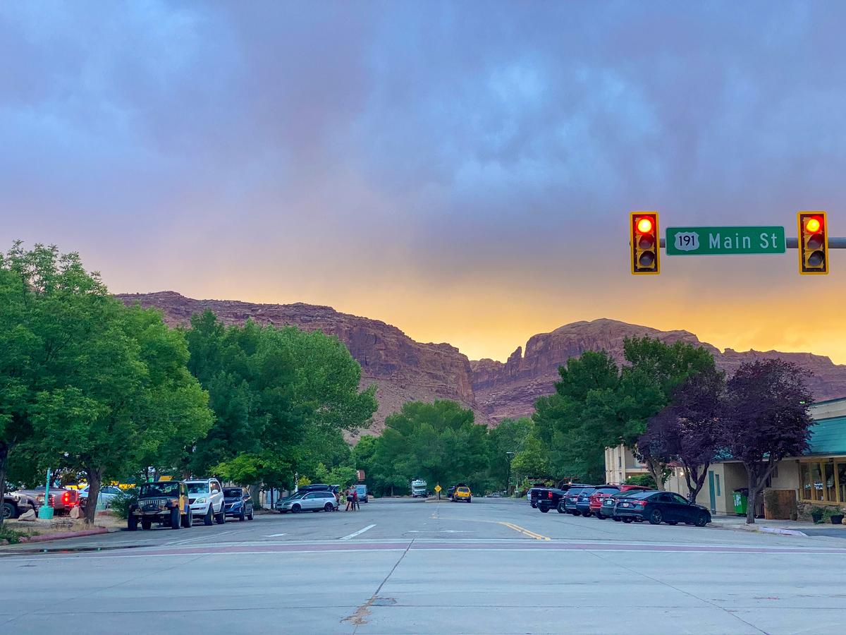
1. Moab
I think that Moab is one of the best places to visit in Utah. Why? This red-rock wonderland completely stole my heart with its dramatic sandstone arches, fiery sunsets, winding canyons, and miles of otherworldly desert trails. After a scenic drive through eastern Utah, I felt like I’d stepped onto another planet—raw, wild, and breathtakingly beautiful!
I spent four adventurous days based in Moab, staying at HTR Moab Lodge & Cottages. I biked on the epic Slickrock Trail and explored the surreal landscapes of Arches National Park, where Delicate Arch at golden hour truly lived up to the hype. I hiked through Canyonlands’ Island in the Sky for sweeping views that felt endless, floated down the Colorado River in a raft, and capped my days with stargazing in some of the clearest night skies I’ve ever seen. The town itself has a laid-back, outdoorsy vibe with plenty of great coffee spots, breweries, and food trucks to refuel between adventures.
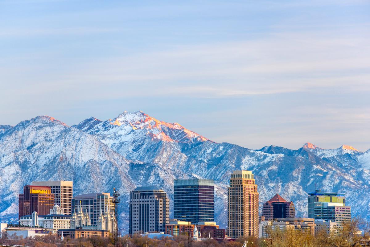
2. Salt Lake City
Salt Lake City was the perfect mix of outdoorsy adventure and surprising urban charm, framed by snow-capped Wasatch peaks, dotted with historic architecture, and filled with a lively food and arts scene. I hopped on the TRAX light rail from the airport straight into downtown (about 20 minutes, $2.50) and stayed at The 5-star Grand America Hotel for two days. With over a million people in the metro area, the city blends urban energy with quick access to nature.
From downtown, you can explore the stately grounds of Temple Square with its soaring spires and manicured gardens, browse the vintage shops and cafés of the Sugar House neighborhood, and then drive just 30 minutes to find yourself in true mountain wilderness. The city feels both accessible and adventurous, a rare blend of urban and alpine.
For an outdoor adventure, you can hike along the trails at Big Cottonwood Canyon, bike along the Jordan River Parkway, tour the Natural History Museum of Utah (my son said it's teenager-approved), and enjoy panoramic views from the Utah State Capitol.
- Location: Map & Directions
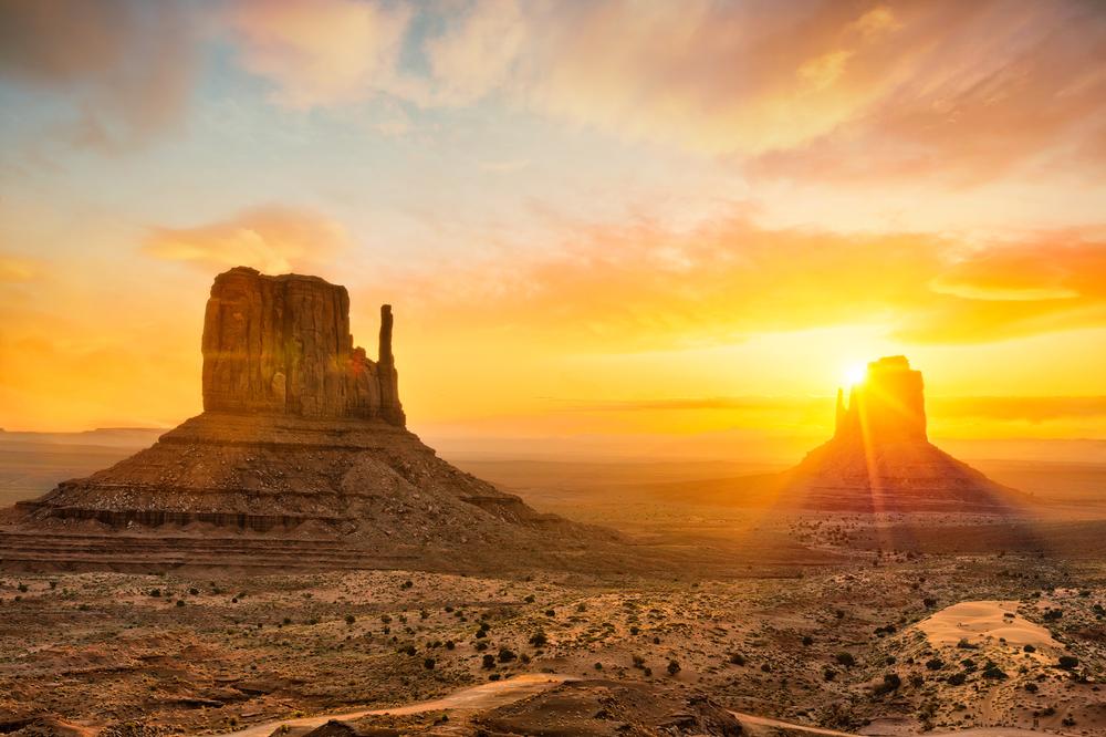
3. Monument Valley
I thought Monument Valley was one of the most iconic landscapes I’ve ever seen...towering sandstone buttes glowing red at sunrise, endless desert horizons, and a sense of timelessness that felt almost spiritual.
From Page, it was a 2-hour 15-minute drive northeast to Monument Valley, where the desert spreads wide under endless sky. The Navajo Nation manages this 92,000-acre park, home to sacred sites and cinematic landscapes.
Driving the 17-mile Valley Drive, I stopped at overlooks with views so familiar from classic Western films they felt surreal in person. I stayed at The View Hotel, perched right on the rim.
You can join a Navajo-led tour into the backcountry, explore hidden arches, petroglyphs, and sacred sites not accessible on your own. You can hike on Wildcat Trail, the only self-guided hike inside the valley, circle West Mitten Butte and enjoy incredible stargazing.
- Location: Map & Directions
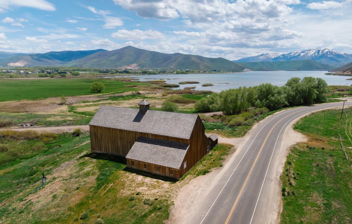
4. Midway, UT
Midway, tucked in the Heber Valley, is a charming alpine village with a quirky Swiss twist with flower-boxed chalets, rolling green meadows, and jagged peaks rising in every direction. It's cozy and storybook-like, but with adventure always just outside the door.
From Salt Lake City, it’s only a 45-minute drive, yet it feels like stepping into another world. I wandered Main Street, sampled artisan cheeses and pastries, and soaked in the nearby Homestead Crater.
In winter, Midway transforms into a snowy playground with cross-country skiing, tubing, and the enchanting Ice Castles (an illuminated frozen fortress straight out of a fairytale). In summer, You can bike on the scenic Provo River Parkway, fly fish and hike. Wasatch Mountain State Park made the perfect backdrop for camping and spotting deer at dusk.
- Location: Map & Directions

5. Canyonlands National Park
Canyonlands National Park is vast, raw, and humbling, a place where endless red-rock canyons, towering mesas, and twisting rivers carve a landscape that feels almost Martian. The scale is so immense it makes you feel wonderfully small.
From Moab, I drove less than 40 minutes to the Island in the Sky district, where overlooks like Mesa Arch and Grand View Point delivered some of the most breathtaking panoramas I’ve ever seen. At sunrise, the arch framed the canyon below in glowing light — one of those must-see moments that feels unforgettable in person.
I explored Needles, a more remote district with spires and colorful sandstone formations, hiking through red-and-white striped rocks and narrow slot canyons. The Maze district remained a wild frontier — remote and rugged, best suited for seasoned adventurers.
- Location: Map & Directions
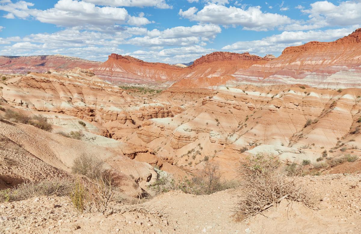
6. Grand Staircase-Escalante
I Grand Staircase–Escalante National Monument was one of the most adventurous and untamed landscapes in Utah — sprawling slickrock plateaus, winding slot canyons, hidden waterfalls, and a vastness that makes you feel like an explorer charting new ground.
Driving along Scenic Byway 12 (one of the most beautiful highways in America), I stopped at overlooks where layers of red, orange, and cream-colored cliffs stacked like a giant staircase across the horizon. I camped under star-filled skies and felt the silence of this remote desert wrap around me.
I hiked into the famous slot canyons of Peek-a-Boo and Spooky Gulch — twisting sandstone corridors so narrow I had to shimmy sideways through. At Lower Calf Creek Falls, I was rewarded with a stunning 126-foot waterfall cascading into a cool, turquoise pool surrounded by ferns and cottonwoods. Boulder’s Anasazi State Park Museum gave me a glimpse of ancient Puebloan life, and along Hole-in-the-Rock Road I discovered arches, natural bridges, and endless backcountry trails.
- Location: Map & Directions
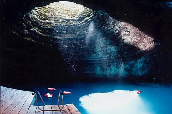
7. Homestead Crater
I think that Homestead Crater is one of the best places to visit in Utah. Why? The Homestead Crater is a geothermal hot spring hidden inside a giant beehive-shaped limestone dome. Floating in its warm turquoise waters, sunlight streaming through a hole in the rock above, felt both surreal and serene.
Just outside Midway, I walked through a tunnel carved into the rock and emerged inside the crater — steam rising, mineral walls glowing, and the 65-foot-deep pool shimmering in blues and greens. At 90–96°F year-round, the water was perfect for soaking, but also for snorkeling, paddleboarding, and even scuba diving (the only warm-water scuba spot in the continental U.S.!).
I booked a timed entry in advance (it’s required), then spent my session swimming in the mineral-rich water and just gazing up at the sky through the natural skylight above. The acoustics made it feel like being in a hidden cavern cathedral.
- Location: Map & Directions
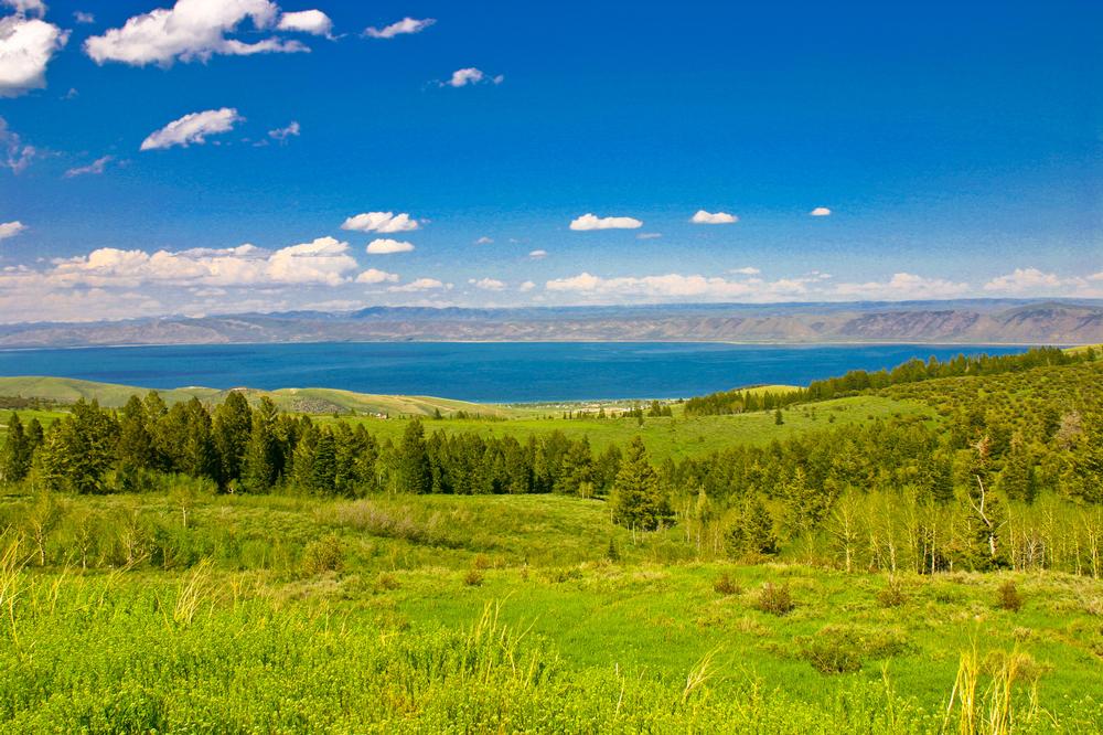
8. Bear Lake
Bear Lake was pure magic, a vast alpine lake so turquoise it’s nicknamed the “Caribbean of the Rockies.” The water sparkled under the sun, framed by rolling mountains and small lakeside towns that made the whole place feel both lively and laid-back.
From Garden City, I rented a kayak and paddled across the glassy surface, watching the colors shift from sapphire to deep aquamarine. I relaxed on sandy beaches, biked the 50-mile loop road around the lake, and sampled the famous local raspberry shakes (worth every calorie!). In the evening, I watched the sky turn pastel pink as the lake reflected the fading light.
In summer, Bear Lake is all about water sports, hiking, and fresh fruit stands. In winter, the area transforms into a snow-dusted wonderland for snowmobiling, ice fishing, and cross-country skiing. Either way, it feels like a year-round escape.
- Location: Map & Directions
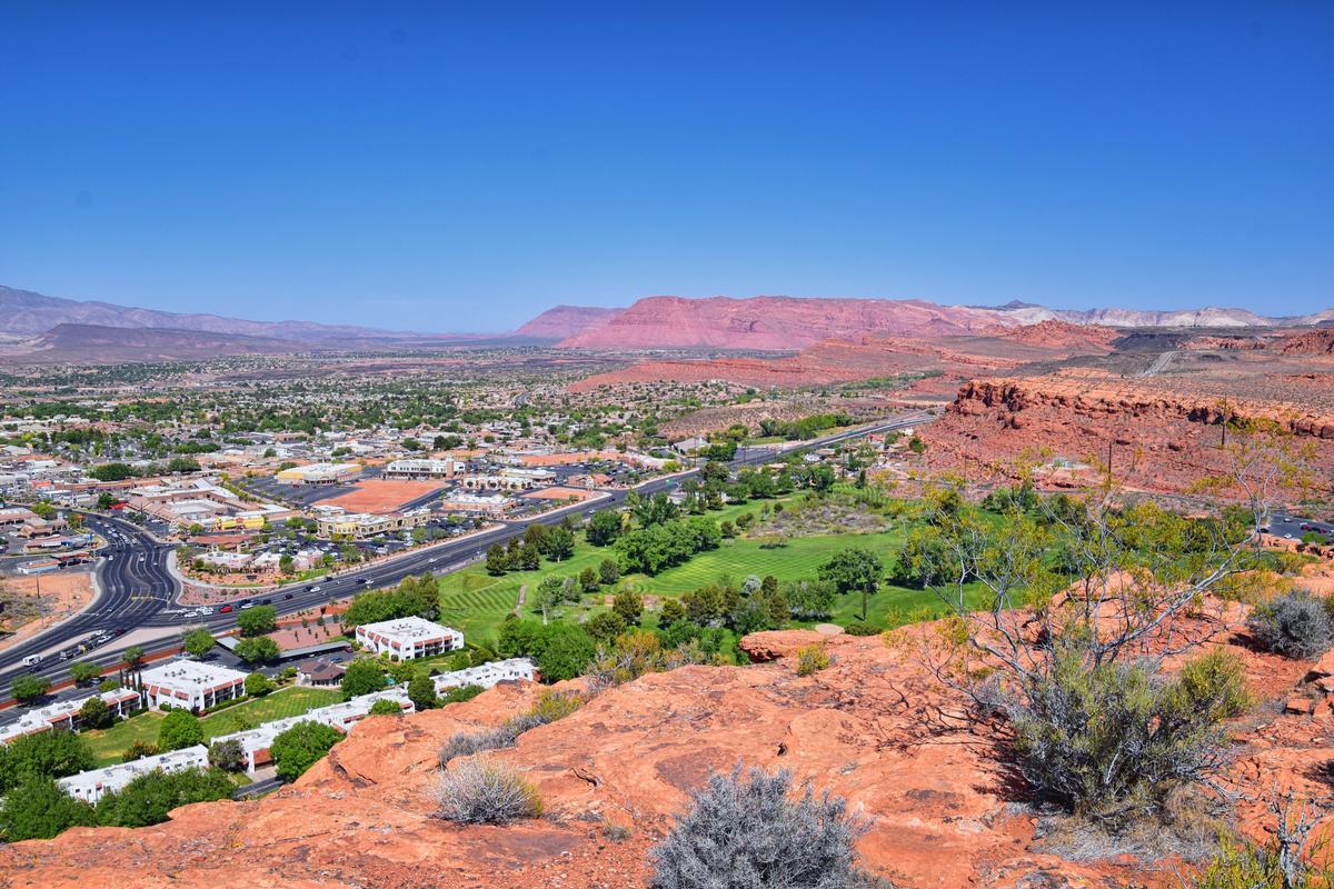
9. St. George
St. George was the ultimate desert escape — red sandstone cliffs glowing in the sun, palm trees swaying against a backdrop of mountains, and a laid-back vibe that made it the perfect base for adventure. I caught a shuttle from Las Vegas to St. George (about 2.5 hours, $45).
From town, I explored the red rock trails of Pioneer Park, where scrambling across slickrock felt like a mini–Arches experience. I wandered through the charming historic district with its old brick buildings, art galleries, and cafés, then drove just 20 minutes to Snow Canyon State Park — a stunning blend of petrified dunes, lava flows, and fiery sandstone canyons.
I day-tripped to nearby Zion National Park (just under an hour away) for jaw-dropping hikes, but also loved the quieter gems around St. George: kayaking at Sand Hollow Reservoir, climbing in Black Hill, and stargazing in the desert. The mild climate makes this a year-round destination — I biked in the sunshine in January!
- Location: Map & Directions
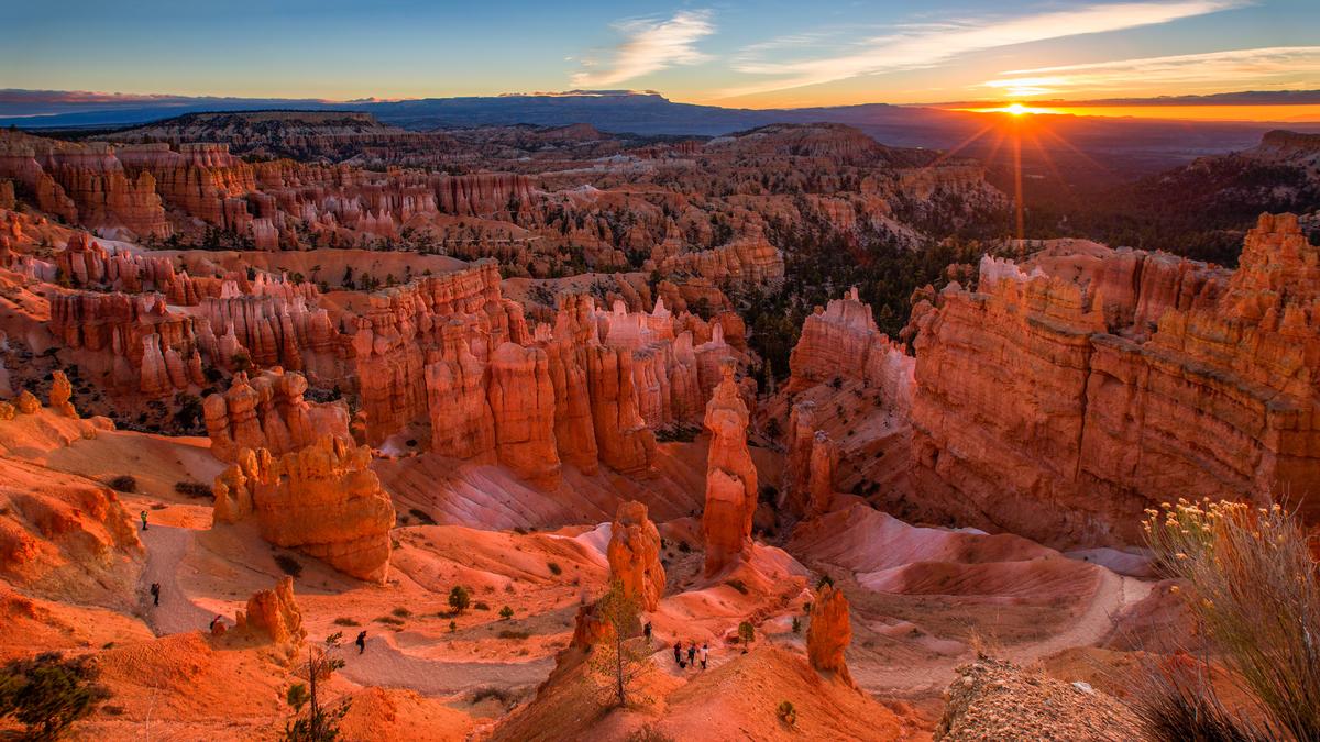
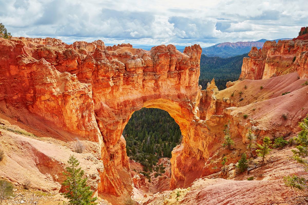
10. Bryce Canyon
Bryce Canyon was absolutely otherworldly, a vast amphitheater of fiery hoodoos glowing orange, pink, and gold under the sun. The landscape felt like stepping into a natural cathedral sculpted by wind, frost, and time.
From the rim, I gazed down at thousands of spindly hoodoos clustered together in surreal formations. Sunrise at Sunrise Point was magical — the hoodoos slowly shifting from deep purple shadows to blazing orange as the first light hit. Later, I hiked the iconic Navajo Loop and Queen’s Garden Trail, winding down among towering stone spires, arches, and twisting switchbacks.
Driving the scenic 18-mile road, I stopped at overlooks like Bryce Point, Natural Bridge, and Rainbow Point, each offering a new angle of the canyon’s sweeping beauty. At night, the stargazing was unforgettable — Bryce is one of the darkest skies in North America, where the Milky Way blazed overhead.
- Location: Map & Directions
- Bryce Canyon website
Conclusion
After exploring so many destinations, I’ve realized that Utah is one of the most spectacular states to visit in the USA. From red rock deserts to alpine lakes, every corner of the state offers something unusual, beautiful, and unforgettable.
Booking Checklist
1. Book Your Flight - I use Expedia because I like their mobile app with my itinerary. They've helped me re-book flights on many occasions. Once you reach their Gold tier, support is especially good.
2. Book Your Hotel - I use Booking.com or Expedia, depending on my destination.
3. Book Your Rental Car - I use Expedia.
4. Book your tours on Viator or Get Your Guide.
