
-
What is elevation?
- Elevation describes how high or low a location is in relation to the mean sea level of Earth. It is measured in either feet or meters.
-
How is elevation used?
- Elevation has various uses, such as in architecture and town planning. It can also influence an area's climate, with low-elevation areas typically experiencing warmer temperatures and a reduced chance of snowfall.
-
Can a location's elevation be below sea level?
- While most locations have an elevation above sea level, it is possible for some very low locations to have elevations lower than sea level.
Elevation Basics:
1. Lowest Elevation in the United States
© PixHound/stock.adobe.com
-
Why do many major American cities have relatively low elevations?
- Many major American cities are located near coastal areas, meaning they tend to have relatively low elevations, typically around 500 feet (152 m) or less.
-
What causes the elevation differences across the United States?
- The United States features a vast array of landscapes, including mountain ranges, canyons, high plains, and more, resulting in very different elevations from one state to the next.
-
How does elevation change as you move inland?
- In general, the rule is that as one moves further inland, the average elevation will start to rise.
-
What are the lowest states in terms of elevation?
- The lowest states in terms of elevation are Delaware, Florida, and Louisiana, all of which are located on the coast and have large amounts of low-lying coastline.
Elevation Must Know:
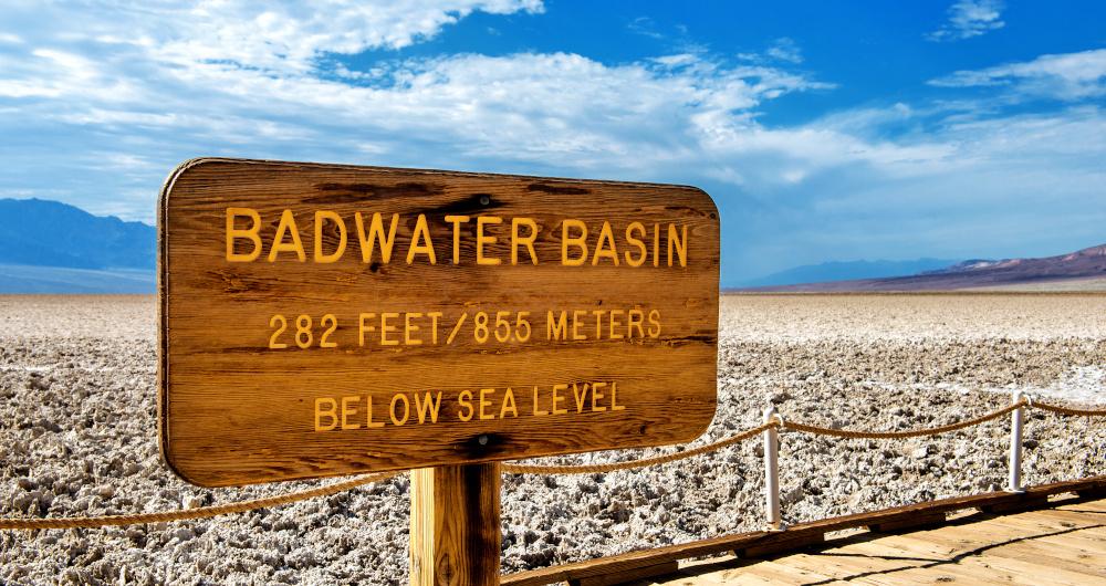
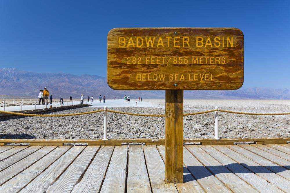
2. Lowest Elevation Point in the United States
© JUAN CARLOS MUNOZ/stock.adobe.com
-
Where is the lowest point in the United States?
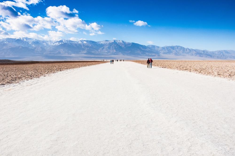
- The point with the lowest elevation in the United States is Badwater Basin, located in Death Valley, California.
-
What are the dimensions of Badwater Basin?
- Badwater Basin has a maximum length of 7.5 miles (12 km) and a maximum width of 5 miles (8 km).
-
What is the elevation of the lowest point in Badwater Basin?
- The lowest point in Badwater Basin is located in the western part of the basin and has an elevation of 279 feet (85 m) below sea level.
-
How does the elevation of Badwater Basin compare to other low points in the world?
- Badwater Basin is one of the lowest points in the entire world. The lowest point in the world is the Dead Sea, which has an elevation of 1,391 feet (424 m) below sea level at its lowest point.
-
What makes Badwater Basin unique?
- Badwater Basin is well-known for its unique salt flats and their hexagonal honeycomb-style formations.
-
Is Badwater Basin hospitable to humans?
- While some plants and animals can survive in the area, Badwater Basin is very inhospitable to humans. The water is completely unsafe for consumption due to its high salt content, and the flats are dangerous because they are filled with mud.
-
Is Badwater Basin a popular tourist destination?
- Despite its inhospitable nature, Badwater Basin and Death Valley remain popular tourist destinations, offering unique views that cannot be replicated anywhere else on Earth.
3. The lowest city in the United States

© MelissaMN/stock.adobe.com
-
What is the lowest city in the United States by elevation?
- The lowest city in the United States in terms of elevation is Calipatria (formerly known as Date City) in California, located in Imperial County. Calipatria has an elevation of 180 feet (50 m) below sea level, making it not only the lowest city in the U.S. but also the lowest in the entire western hemisphere.
-
What is the climate like in Calipatria?
- Due to its unique elevation and location, Calipatria has a very hot desert climate with minimal rainfall and high temperatures for almost the entire year.
-
What is the lowest census-designated place in the United States?
- The lowest census-designated place in the United States is Furnace Creek, located in Death Valley, California. It has an elevation of 190 feet (58 m) below sea level.
-
What makes Furnace Creek notable?
- Furnace Creek has a population of barely two dozen people and is known for being the site of the hottest recorded air temperature on Earth, which reached 134°F (57°C).
4. The lowest State in America
© Navalaney/stock.adobe.com
-
What is the mean elevation of California?
- Despite being home to many of the lowest points in the United States and the western hemisphere, California’s mean elevation is relatively high at 2,900 feet (880 m).
-
What state has the lowest average elevation?
- The state with the lowest average elevation is Delaware, with a mean elevation of just 60 feet (20 m) above sea level.
-
What are the highest and lowest points in Delaware?
- The highest point in Delaware is the Ebright Azimuth, with an elevation of 447 feet (136 m).
- The lowest point in Delaware is at sea level in the Atlantic Ocean.
-
What state has the largest elevation span?
- The state with the largest elevation span (the difference between the highest and lowest points) is Alaska.
-
What is the highest and lowest point in Alaska?
- The highest point in Alaska is Denali, at 20,310 feet (6,190.5 m).
- The lowest point in Alaska is the waters of the Arctic Ocean and Bering Sea, which are at sea level.
-
What is Alaska's total elevation span?
- Alaska has a total elevation span of 20,310 feet (6,190.5 m), which is the difference between Denali and the sea level waters.
Map:
Plan Your Trip