
One of the most unique and distinctive monuments in the world, Mount Rushmore is located in the Black Hills of Keystone, South Dakota. Mount Rushmore Elevation: 5,725 feet
Table of Contents
- Why Mount Rushmore Matters
- Quick Facts About the Sculptures
- Understanding the Elevation
- Elevation in South Dakota Context
- What the Elevation Means for Your Visit
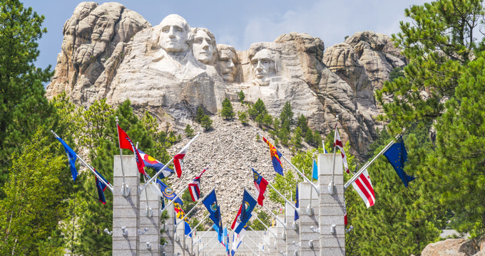
Why Mount Rushmore Matters
If you're looking for a trip that mixes history, nature, and a bucket-list photo op, Mount Rushmore should be at the top. Found in western South Dakota, near the Wyoming border, this giant sculpture carved into a batholith (a large exposed rock) draws millions every year. It spans 1,278 acres, with plenty of trails and stunning views all around.
Quick Facts About the Sculptures
- Presidents: George Washington, Thomas Jefferson, Theodore Roosevelt, and Abraham Lincoln.
- Height: Each head is 60 feet (18 m) tall.
- Origin: Concept by historian Jonah 'Doane' Robinson.
- Sculptor: Gutzon Borglum led the project starting in 1927.
- Timeline: Faces completed between 1934–1939. The plan was originally more ambitious but halted in 1941 due to funding and Borglum’s death.
Tip: Take the Presidential Trail to get different angles and less crowded photo spots.
Understanding the Elevation
Elevation tells us how high something is above sea level and it impacts everything from breathing comfort to weather.
- Mount Rushmore: 5,725 feet (1,745 m)
- Keystone: 4,331 feet (1,320 m)
- U.S. average: 2,500 feet (760 m)
Travel tip: Stay hydrated and take it easy on your first day if you're not used to high altitudes.
Elevation in South Dakota Context
South Dakota ranks as the 13th highest state in terms of average elevation.
- Highest Point: Black Elk Peak – 7,244 feet (2,208 m)
- Lowest Point: Big Stone Lake – 968 feet (295 m)
- Mean Elevation: 2,200 feet (670 m)
Other notable elevations:
- Custer: 5,315 feet (1,620 m)
- Lead: ~5,213 feet (1,589 m)
- Rapid City: 3,202 feet (976 m)
Side quest idea: Hike Black Elk Peak for panoramic views just west of Mount Rushmore.
What the Elevation Means for Your Visit
Mount Rushmore’s high elevation brings distinct weather patterns and scenic vistas.
- Summers: Warm with highs around 78°F (25°C); expect rain and thunderstorms.
- Winters: Cold and snowy, with over 50 inches of snow annually.
Packing tip: Bring layers and a rain jacket, even in summer. Good walking shoes are essential.
Experience tip: Visit early morning or late afternoon for better light and smaller crowds.
Plan Your Trip