
Last Minute Family Vacations

Planning the perfect family getaway doesn’t always require months of preparation—sometimes the best memories come from last-minute adventures. Having traveled with family on both quick escapes and longer trips, I’ve found that spontaneous vacations can be some of the most fun and rewarding experiences of all.
I discovered destinations that are easy to reach, family-friendly spots with plenty to do, and relaxing places where parents and kids alike can unwind. From beach getaways to national parks and lively cities, there are countless options for a stress-free, last-minute family trip. Here are the ones I recommend, and I think you’ll enjoy them too.
1. Orlando: Wonder and a Well-Timed Breather
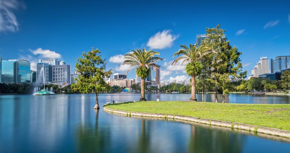
We flew about 2.5 hours from Austin to Orlando, a city that grew from citrus groves and cattle ranches into one of America’s most visited destinations.
Orlando instantly came to mind when we were searching for a last-minute family vacation spot, and it turned out to be the perfect choice. I loved how easy it was to plan, with countless options for fun, relaxation, and family-friendly adventure all in one place.
We started with the theme parks, and of course Walt Disney World and Universal Orlando were absolute highlights. Watching my kids’ faces light up at the parades, rides, and character meet-and-greets was pure joy. Even with little planning, we found plenty of affordable ways to enjoy the parks, from quick-service meals to off-peak evening visits.
One of my favorite discoveries was exploring beyond the big attractions. ICON Park on International Drive gave us a hidden gem vibe with its giant observation wheel, casual dining, and fun arcades. It was such a cool way to spend an afternoon without the crowds.
We also carved out time for quieter moments, like visiting Lake Eola Park downtown. Renting swan boats and enjoying the skyline views made for a spectacular family memory that felt different from the usual Orlando experience.
Food was another adventure. From themed restaurants that kept the kids entertained to international cuisine along I-Drive, we never ran out of choices. Everything felt easy and family-oriented, which I really appreciated on a spontaneous trip.
For me, Orlando is one of the best last-minute family getaways. With its mix of thrilling parks, hidden local spots, and plenty of joyful experiences for all ages, it’s a place where every day turns into a memory worth keeping.
Check prices at Hilton Orlando.
2. Mount Hood Railroad: Windows, Whistles & Wildflower Hills
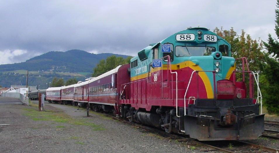
We drove about 1.5 hours east from Portland along the Columbia River Gorge to Hood River, home of the Mount Hood Railroad.
Riding the Mount Hood Railroad in Hood River, Oregon, felt like stepping into a blend of history, scenery, and pure adventure. I loved how the journey carried us through orchards, forests, and mountains, creating a joyful experience that was both relaxing and exciting at the same time.
We boarded in downtown Hood River, and the vintage train immediately gave me the sense of discovering a hidden gem. The restored cars, friendly staff, and nostalgic atmosphere made me feel like I was part of something timeless.
As we rolled along the tracks, the views were absolutely spectacular. I couldn’t take my eyes off the orchards in bloom, the rolling hills, and of course the stunning sight of Mount Hood itself rising in the distance. It felt like the coolest way to take in Oregon’s natural beauty without ever leaving my seat.
One of my favorite parts was learning about the history of the railroad and its role in the region. Hearing stories of how it once carried goods and people through the Gorge made the ride even more meaningful.
Families will especially love the themed excursions, from holiday trains to wine tours. It felt affordable, fun, and flexible enough that everyone—kids and adults alike—found something to enjoy.
For me, the Mount Hood Railroad is one of Oregon’s most underrated attractions. It’s not just a ride—it’s an experience that combines history, scenery, and joyful moments, leaving you with memories as timeless as the train itself.
3. Pelican Lake Calm & Birch Forest Cabin Days at Birch Forest Lodge
We drove about 4.5 hours north from Minneapolis to Pelican Lake near Orr.
Pelican Lake, near Orr in northern Minnesota, gave me the perfect mix of peaceful nature and exciting adventure. I loved how the lake stretched wide and open, with its clear waters and quiet shores making it feel like a hidden gem tucked away in the Northwoods.
We spent most of our time on the water, and I couldn’t get enough of the fishing. Pelican Lake is known for its walleye, northern pike, and bass, and every cast felt like it might bring in something spectacular. Watching the kids reel in their catches was pure joy—it made the whole trip even more memorable.
Beyond fishing, we explored the lake by boat and canoe. With its countless bays, islands, and winding shoreline, every outing felt like discovering something new. It was one of my favorite parts of the trip, especially when we found quiet coves perfect for swimming and relaxing.
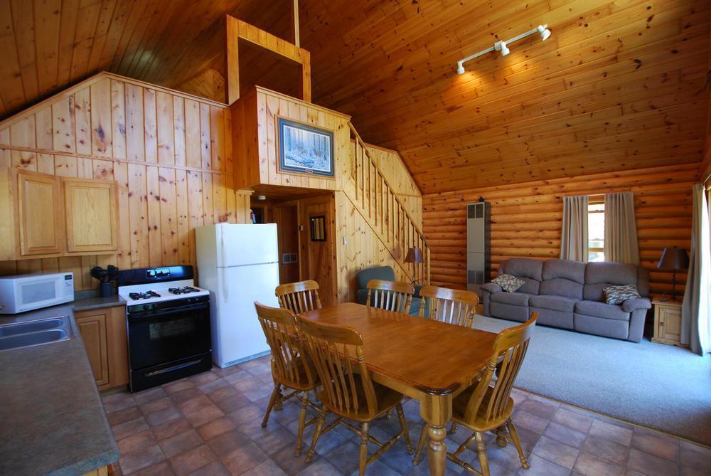
In the evenings, we gathered at a lakeside cabin, grilling up fresh fish and watching the sun set over the water. The skies turned shades of pink and orange that felt absolutely magical, and I realized why this place is such a cool summer escape.
Wildlife was everywhere too—loons calling across the water, eagles soaring above, and deer moving quietly along the treeline. It made me feel fully connected to nature in the most joyful way.
For me, Pelican Lake near Orr is one of Minnesota’s most underrated vacation spots. With its spectacular fishing, family-friendly atmosphere, and serene beauty, it’s the kind of place that makes you want to return year after year.
4. Lehi, Utah: Curiosity, Gardens & a Forkful of Comfort
We drove about 30 minutes south from Salt Lake City to Lehi, a city founded in 1850 and one of Utah’s oldest settlements.
Lehi, nestled in Utah Valley between Salt Lake City and Provo, surprised me with how much there was to see and do for families, history lovers, and outdoor enthusiasts. I loved how the city felt both modern and deeply connected to its roots, making it a joyful stop along the Wasatch Front.
One of my favorite highlights was Thanksgiving Point, a spectacular complex that truly had something for everyone. From the Museum of Natural Curiosity, where kids could explore hands-on exhibits, to the Museum of Ancient Life with its massive dinosaur displays, it felt like a hidden gem packed with discovery. I especially loved wandering through the Ashton Gardens, where peaceful paths and colorful blooms made it the coolest outdoor retreat.
We also spent time in historic downtown Lehi, where the small shops and cafés gave me a warm sense of community. The Lehi Roller Mills, a local landmark, added a touch of history I really appreciated—it’s famous for being featured in *Footloose*, and it felt like stepping back in time.
For outdoor fun, we ventured to the nearby Traverse Mountains and Utah Lake. Hiking trails and wide-open views gave me that spectacular mix of fresh air and scenery that Utah does so well. It was affordable adventure, and perfect for a quick family getaway.
For me, Lehi is one of Utah’s most underrated cities. With Thanksgiving Point, historic charm, and easy access to nature, it’s a place that combines learning, fun, and relaxation in the most joyful way possible.
Check prices at Hilton Garden Inn Lehi.

5. New York City Wonder & Whimsy
I lived in New York City for ten years, so showing up as a visitor felt strange at first. But something about coming back without a schedule reminded me why I loved it so much in the first place. We let the city unfold instead of chasing it.
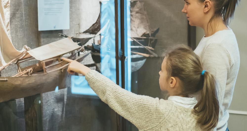
We started at the Museum of Interesting Things, tucked away in SoHo. It’s not flashy, just shelves and tables of vintage contraptions, but it got all of us talking. It was quirky and small, but memorable.
In Brooklyn, Private Picassos gave us a moment to slow down. We joined a family art class, nothing fancy, just a bright space, a few brushes, and the hum of kids deep in creative focus.
From there, we headed to Casa Kids, a design showroom I used to pass without noticing. It’s still clever and practical, still fun to climb on everything.
We ended the afternoon at Greenlight Bookstore in Fort Greene. I used to come here for author talks. This time, we curled into the kids’ section and let him flip through pages while we browsed the front table. We left with a few books and nowhere in particular to be.
That night, by pure luck, we landed at the Latke Festival at the Brooklyn Museum. It smelled like fried potatoes and warm spices. We wandered from booth to booth, sampling sweet-and-savory bites and laughing when my husband accidentally dipped a sour cream latke in hot sauce. It felt like home again, just louder, crispier, and a little more delicious.

6. Angel Fire: Snowfall, Stillness & Just Enough Speed
We drove about 2 hours northeast from Santa Fe to Angel Fire, a high-mountain village in the Moreno Valley of the Sangre de Cristo range.
Angel Fire, tucked into the Sangre de Cristo Mountains of northern New Mexico near Taos, felt like a true mountain escape from the moment I arrived. I loved how this small resort town blended outdoor adventure with a laid-back vibe, making it a joyful getaway in every season.
In winter, we hit the slopes at Angel Fire Resort, and it quickly became one of my favorite ski destinations. The trails were family-friendly yet exciting, with spectacular mountain views at every turn. I loved that it felt less crowded than some of the bigger resorts, giving us more room to truly enjoy the snow.
During summer, the vibe shifts into hiking, biking, and lake fun. We explored the scenic trails around Monte Verde Lake, where kayaking and fishing made for a relaxing afternoon. It felt like discovering a hidden gem, and the peaceful setting gave me time to slow down and reconnect with nature.
Another highlight was the Vietnam Veterans Memorial State Park nearby. Standing in such a meaningful place, surrounded by mountains, gave me a cool sense of history and reflection that added depth to the trip.
Evenings in Angel Fire were just as special. Whether enjoying a casual, affordable meal at a local restaurant or sitting outside watching the sunset paint the mountains pink and gold, I felt completely at ease.
For me, Angel Fire is one of the most underrated destinations in New Mexico. With its spectacular mix of adventure, history, and mountain charm, it’s the kind of place where every season feels like the right time to visit.
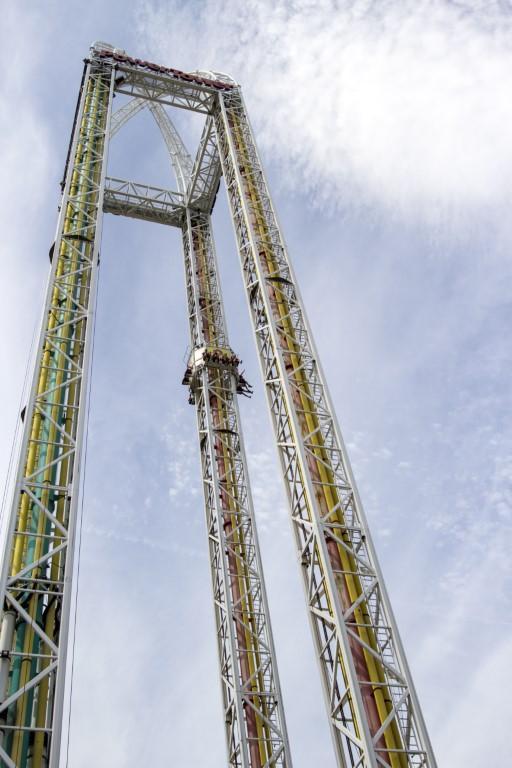
7. Cedar Point: Adventure & Lake Erie Light
We drove about 1 hour west from Cleveland to Cedar Point, a legendary amusement park on a Lake Erie peninsula.
Cedar Point in Sandusky, Ohio, turned out to be one of the coolest family vacations we’ve ever taken. Known as the “Roller Coaster Capital of the World,” the park had something for everyone, and I loved how joyful the atmosphere felt from the moment we walked through the gates.
For the thrill-seekers in the family, the towering coasters were spectacular. Watching the kids conquer Millennium Force and Steel Vengeance was exciting, while I enjoyed classics like Gemini that felt just as fun without the intensity. The variety made it easy for us to ride together and still have plenty of options for all comfort levels.
One of my favorite surprises was how family-friendly Cedar Point actually is. Beyond the big rides, we spent time at Planet Snoopy and Camp Snoopy, where younger kids had smaller coasters, gentle rides, and playful shows. It gave me that hidden gem feeling in the middle of such a massive park.
We also loved Cedar Point Shores Waterpark, where lazy rivers, wave pools, and slides gave us a refreshing break from the roller coasters. It felt like two vacations in one, and the kids couldn’t get enough of the water fun.
Evenings were just as memorable. From grabbing affordable pizza and funnel cakes to sitting along the beach watching the sun set over Lake Erie, it felt like a perfect way to wind down after a full day of excitement.
For me, Cedar Point is one of the absolute best family vacation spots in the Midwest. With its spectacular rides, hidden family areas, and unique lakefront setting, it’s a place where every age finds joy and every visit creates lasting memories.
Check prices at Hotel Breakers, Cedar Point’s historic beachfront resort dating back to 1905.
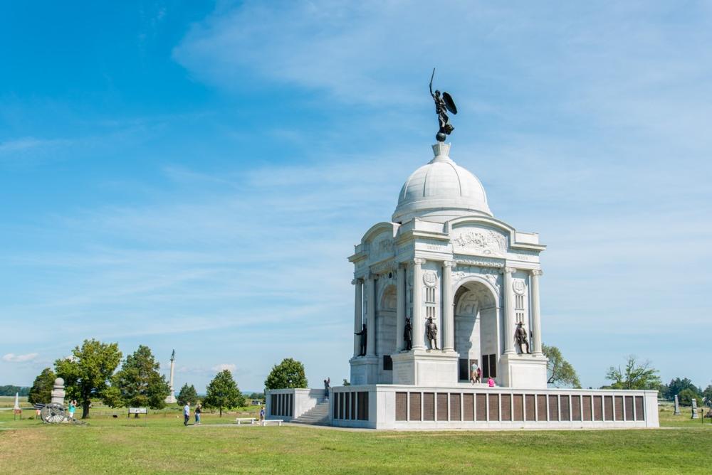
8. Gettysburg: Cannon Echoes & Quiet Lessons
We drove about 1.5 hours north from Washington, D.C. to Gettysburg, site of the pivotal Civil War battle in July 1863.
Gettysburg, in southern Pennsylvania, gave me one of the most meaningful and memorable trips I’ve ever taken. I loved how the town blended deep history with small-town charm, making it both educational and joyful for a family vacation or a solo getaway.
We started with the battlefields, and standing on those rolling hills where so much history unfolded felt absolutely spectacular. The monuments, trails, and scenic overlooks gave me a chance to reflect while also appreciating the quiet beauty of the countryside.
One of my favorite highlights was visiting the Gettysburg Diorama. Seeing the entire battlefield laid out in miniature, with lights and narration bringing the three days of battle to life, gave me a clear and exciting perspective that made everything we saw outside more meaningful. It truly felt like a hidden gem for understanding the scope of Gettysburg.
Downtown Gettysburg was another joy. We explored antique shops, local cafés, and historic taverns that gave the town such a unique character. I especially loved how affordable and welcoming everything felt, making it easy to enjoy without rushing.
In the evenings, we joined a ghost tour through the historic streets, and it added a fun, unusual twist to the history we had been learning all day. The mix of storytelling and atmosphere made the experience unforgettable.
For me, Gettysburg is one of the most underrated historic destinations in America. Between the battlefield, the Gettysburg Diorama, and the welcoming downtown, it’s a place where history comes alive while still offering plenty of modern charm and joyful moments.
Check prices at Gettysburg Hotel.
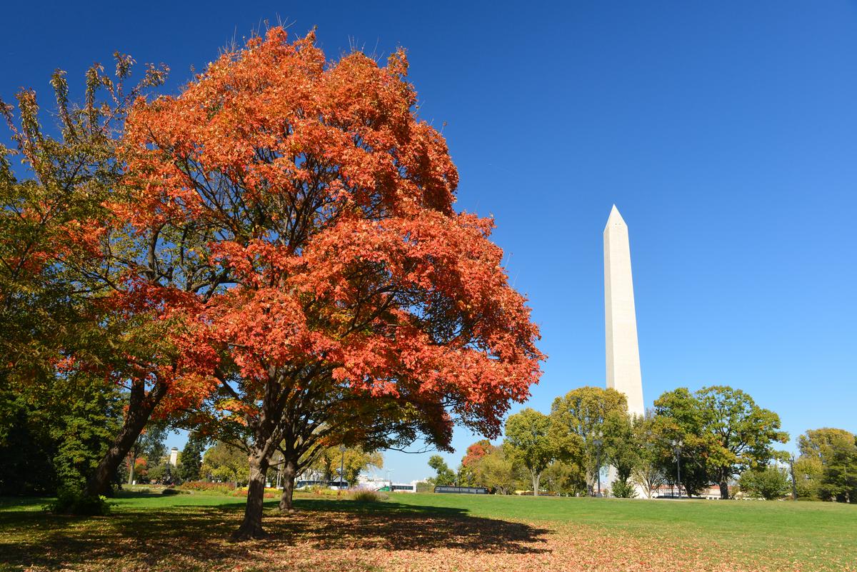
9. Washington, DC Layers: Old Stones, New Stories
Washington, DC, has always been one of my favorite cities to explore, and this trip reminded me why. I loved how the city blends powerful history with joyful modern experiences, giving me something new every time I visit.
We started with the classics—the monuments and museums along the National Mall never fail to impress. Standing before the Lincoln Memorial and gazing toward the Capitol felt absolutely spectacular, a reminder of the country’s history and ideals.
But what I really enjoyed was discovering spots beyond the Mall. Visiting Dumbarton House in Georgetown was a hidden gem highlight. The 18th-century Federal-style mansion, with its period furnishings and gardens, gave me a cool glimpse into early American life in a peaceful setting away from the crowds.
Food was a huge part of the trip, and Washington, DC, delivered in the best way possible. We grabbed casual bites at Fish Taco, where the flavors were fresh, affordable, and full of personality. Dinner at Osteria Morini by the waterfront was spectacular, with pasta dishes that reminded me of Italy. For a touch of history, 1789 Restaurant in Georgetown felt refined and timeless, while Founding Farmers & Distillers gave me that modern, lively farm-to-table vibe. And of course, no visit is complete without Old Ebbitt Grill—the iconic DC institution where oysters and classic American dishes made the evening unforgettable.
For me, Washington, DC, is more than just politics and monuments. Between the incredible dining scene, hidden gems like Dumbarton House, and the city’s spectacular mix of history and modern life, it’s one of the coolest destinations in the country for a family vacation, romantic weekend, or even a last-minute getaway.

10. Emporia, Kansas: Chalk Murals & Prairie Skies
We drove about 1.5 hours southwest from Kansas City to Emporia, a college town with a proud civic history.
Emporia, tucked into the Flint Hills of east-central Kansas, surprised me with its warm community spirit and unique mix of history, culture, and small-town charm. I loved how the city felt inviting from the start, making my visit both joyful and memorable.
We began downtown, where the historic brick buildings, murals, and locally owned shops gave me a hidden gem vibe. Stopping into cafés and boutiques, I felt connected to the heart of the city—it was affordable, welcoming, and full of character.
One of my favorite highlights was visiting the National Teachers Hall of Fame. Learning about the educators honored there gave me a cool sense of pride and perspective, and it reminded me how meaningful Emporia’s contributions are to the country’s story.
The William Allen White House State Historic Site was another stop that stood out. Touring the home of the Pulitzer Prize–winning journalist offered both history and inspiration—it felt like stepping back in time while learning about a man who shaped public thought in Kansas and beyond.
Outdoors, I enjoyed exploring the nearby Flint Hills National Scenic Byway. The rolling prairies were absolutely spectacular, especially at sunset, and I loved how easy it was to take in that wide-open Kansas beauty just minutes from town.
For me, Emporia is one of the most underrated small cities in the Midwest. With its joyful downtown, meaningful history, and stunning natural surroundings, it’s a place that left me feeling refreshed, inspired, and eager to return.
11. Why These Last Minute Family Vacations Worked for Us
Looking back on our last-minute family vacations, I loved how each place gave us something special. Orlando was pure magic with its theme parks and hidden gems, while Mount Hood Railroad offered a cool, scenic ride through Oregon’s beauty. Pelican Lake near Orr became our hidden fishing paradise, and Lehi, Utah, surprised us with family fun at Thanksgiving Point. Angel Fire brought spectacular mountain adventures, and Cedar Point was the absolute best for thrilling rides and family-friendly fun. Gettysburg gave us history brought to life, especially with the Gettysburg Diorama, while Washington, DC, balanced monuments with amazing meals at spots like Fish Taco and Old Ebbitt Grill. Emporia, Kansas, charmed me with small-town warmth, and every stop proved that spontaneity leads to joyful discoveries.
For me, these last 10 destinations showed that family getaways don’t need months of planning. Whether it’s adventure in Angel Fire, history in Gettysburg, or theme park thrills in Orlando, each place felt like its own hidden gem. Together, they reminded me that the coolest memories often come from the trips we take on a whim.
My personal highlights:
What I love most is how last minute family trips bring out the best surprises, discovering a unique small-town festival, the underrated fun of a lakeside cabin, or the excitement of a spontaneous theme park visit. Each feels special and has quickly become one of my favorite ways to travel with family.
Booking Checklist
1. Book Your Flight - I use Expedia because I like their mobile app with my itinerary. They've helped me re-book flights on many occasions. Once you reach their Gold tier, support is especially good.
2. Book Your Hotel - I use Booking.com or Expedia, depending on my destination.
3. Book Your Rental Car - I use Expedia.
4. Book your tours on Viator or Get Your Guide.
