
- Please support our journalism through affiliate links. Affiliate Disclosure
- Written by our human editors, structured with the help of AI.
Review & FAQ:
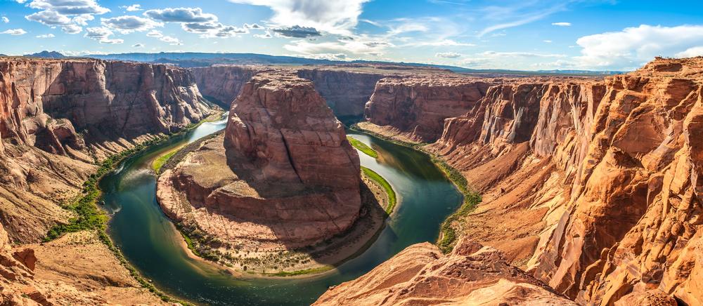
Glen Canyon National Recreation Area stretches from the Orange Cliffs of southern Utah to Lees Ferry in Arizona. This 1.25 million-acre park includes spectacular scenic vistas, magnificent geologic formations, and a colorful and often dramatic human history. One of the many destinations for the adventurous is the Horseshoe Bend, a horseshoe-shaped bend that the Colorado River forms as it meanders around the town of Page, about five miles from Lake Powel and the Glen Canyon Dam. The best way to see Horseshoe Bend is from the high cliff above the river, which can be reached by a mile and half hike from U.S. Route 89. It is a one thousand-foot drop to the river from the overlook.
© Courtesy of milosk50 - Fotolia.com
Rating: ⭐⭐⭐⭐⭐
Cathedral Rock, Sedona
Saguaro National Park
Grand Canyon, Arizona
Antelope Canyon, Monument Valley
Bisbee
Organ Pipe Cactus National Monument, Arizona
Barringer Crater, Arizona
Montezuma Castle National Monument
Lake Powell, AZ
Havasu Falls, AZ
Hoover Dam
Superstition Mountains
Tumacacori National Historical Park, Arizona
Horseshoe Bend, Glen Canyon National Recreation Area
The Wave
Paria Canyon-Vermilion Cliffs Wilderness
Papago Park
Glen Canyon Dam and Bridge, Arizona
Tonto National Monument - 2 hour 20 minute Weekend Getaway from Phoenix
Spur Cross Ranch Conservation Area
Canyon De Chelly National Monument
Petrified Forest National Park, Arizona
Agathla Peak, Monument Valley
Plan Your Trip
Get Ready to Go!
- Search flights and stays nearby.
- Book your tour or local activity.
- Book your car rental.
Need some more help?
Go to travel reservations.