
Discover the elevation of Silverton—a high-altitude mining town nestled deep in the San Juan Mountains of southwestern Colorado. With a rich mining history, extreme terrain, and alpine charm, Silverton stands tall as one of the highest towns in the United States.
Table of Contents
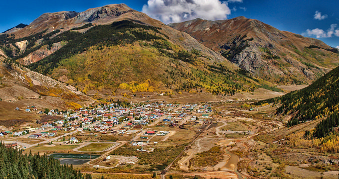
Where is Silverton?
- Location: Silverton is located in San Juan County, Colorado, deep in the San Juan Mountains of the southwestern part of the state.
- Nearby Connections: Closely linked to Durango via the historic Durango and Silverton Narrow Gauge Railroad.
City Profile
- Status: A statutory town and the county seat of San Juan County.
- Area: Only 0.85 square miles.
- Population: Home to a small community of around 630 people.
- Heritage: Most of the town is part of a National Historic Landmark District.
Elevation Basics
- Elevation: Silverton sits at an altitude of 9,318 feet (2,840 m) above sea level—making it one of the highest towns in the U.S.
- Founded: Established in 1874 as a silver mining hub.
- Early Inhabitants: Originally inhabited by native Ute people before white settlers arrived.
- Modern economy: Now relies heavily on tourism, especially historical and mountain recreation.
Must-Know Elevation Facts
- Elevation definition: Indicates how high a place is above sea level.
- U.S. city comparison: Most U.S. towns and cities are built at 500 feet (152 m) or less.
- Ski resort elevations:
- Silverton Mountain: Top elevation of 13,487 feet (4,111 m).
- Kendall Mountain: Peaks at 13,340 feet (4,066 m).
- Nearby city elevation:
- Durango: 6,512 feet (1,988 m)
- Leadville: Slightly higher at 10,152 feet (3,094 m)
- Colorado mean elevation: 6,800 feet (2,070 m)—the highest of any U.S. state.
- Other major Colorado city elevations:
- Denver: 5,280 feet (1,609 m) – "Mile High City"
- Aurora: 5,472 feet (1,668 m)
- Colorado Springs: 6,033 feet (1,839 m)
Climate and Tourism
- Climate type: Alpine subarctic climate with cold temperatures year-round.
- Freezing conditions: Temperatures regularly drop below freezing throughout the year.
- Average temperatures:
- January: Highs of 34°F (1°C), lows of -2°F (-19°C).
- July: Highs of 73°F (23°C), lows of 38°F (3°C).
- Precipitation:
- Rain: Light rain year-round.
- Snow: Over 150 inches annually.
- Top activity: Riding the historic Durango and Silverton Narrow Gauge Railroad.
- Railroad facts:
- Dating back to the late 19th century.
- Runs 45 miles with a 3-foot (914 mm) track gauge.
- Nearby attractions:
- Silverton Mountain – Opened in 2002; extreme terrain; for expert skiers and snowboarders.
- Features 1,819 acres of skiable terrain and thousands more in adjacent backcountry.
Plan Your Trip