
Day Trips in Arizona

Not sure which place to visit in Arizona? Well, you are in the right place! I discovered breathtaking natural wonders, vibrant cities filled with culture and history, and quiet escapes perfect for relaxation during my recent four week road trip across the state. From family-friendly adventures to outdoor thrills, Arizona has something for every kind of traveler.
This is exactly why I decided to share my favorite things in Arizona so that you can use my guide as an inspiration to plan your own road trip. Here are the places I recommend for a day trip, weekend getaway or a longer vacation that I hope you'll enjoy too.
- Best Day Trips in Northern Arizona
- - Flagstaff - Camp Verde - Grand Canyon - Sedona - Payson - Kingman
- Best Day Trips in Southern Arizona
- - Willcox - Green Valley - Tucson
- Best Day Trips in Central Arizona
- - Mesa - Cave Creek - Scottsdale - Apache Junction - Phoenix
- Best Day Trips in Western Arizona
- - Yuma - Parker
Best Day Trips in Northern Arizona
From dramatic red-rock canyons and cool mountain forests to historic Route 66 stops and scenic desert vistas, this region offers incredible variety within just a few hours’ drive.
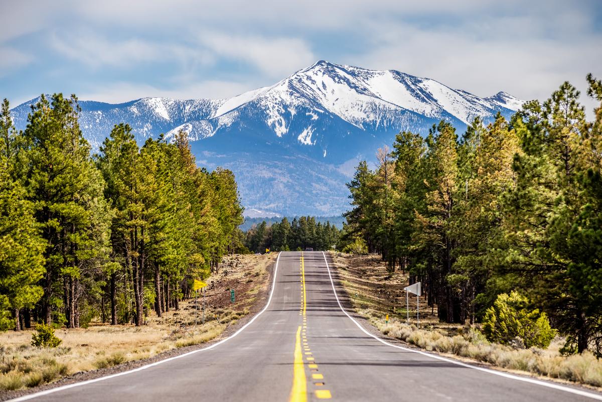
Flagstaff
I loved how this city blended its rugged mountain-town roots with a lively, creative spirit and I think it's one of the best places to visit in Arizona. Flagstaff has a lovely vintage downtown that we had so much fun exploring. In addition, we were surrounded by beautiful nature and many outdoor activities.
Flagstaff felt like an underrated mountain gem tucked near the San Francisco Peaks, which was already magic.
First thing we did was grab coffee downtown, and walking along Route 66 felt like an exciting, vibrant experience that was honestly one of my favorite starts ever.
Flagstaff sits close to the Grand Canyon and near Sedona, which makes it the absolute best base for exploring northern Arizona without rushing.
After breakfast we explored Lowell Observatory, and it was such a cool, unique place where science and history mix in a way that feels unusual but joyful.
The pine trees everywhere made the air feel fresh and dreamy, and we kept saying how this place was an amazing underrated escape compared to hotter desert towns.
Next we drove up Snowbowl Road near the mountains, and the views were spectacular, affordable, and honestly looked even better than in the photos.
By afternoon we wandered around local shops and breweries, and it felt like a relaxed family or romantic vibe depending on your mood.
Dinner was downtown again, and eating local food in this hidden, walkable area was one of the best experiences of the trip.
At night we just walked outside to stargaze, since Flagstaff is a dark-sky city, and that kind of natural magic is hard to beat.
After landing at Flagstaff Pulliam Airport, I grabbed a rental car and based myself at the boutique Weatherford Hotel for three relaxing days.
What I loved best:
Stargazing at Lowell Observatory was my personal highlight.
Camp Verde
Set among the red rock landscapes and lush river valleys of central Arizona, for me, Camp Verde is one of the most unexpectedly beautiful day-trip destinations in the state.
We started at Montezuma Castle National Monument, where the ancient cliff dwellings tucked into limestone cliffs immediately pulled us into another time. Standing together, looking up at homes built nearly a thousand years ago, felt both humbling and quietly romantic.
My favorite part was walking along the trails near Beaver Creek, side by side, with cottonwood trees overhead and the sound of water nearby—it was peaceful in a way that made everything slow down. Downtown Camp Verde had a relaxed, welcoming charm, with small museums, local shops, and cafés that encouraged us to wander without any rush.
We stopped for lunch at a local spot and shared hearty Southwestern comfort food, the kind that feels especially satisfying after a morning of exploring.
I loved browsing the local shops filled with Native-inspired art, handmade crafts, and desert-themed souvenirs, picking out little reminders of the trip to take home.
A hidden highlight was visiting a nearby winery in the Verde Valley, where we sipped Arizona wine and soaked in the views of rolling hills and vineyards—an unexpectedly romantic pause in the day.
We also learned about the area’s deep Native American and frontier history, which added layers of meaning to everything we’d seen and made the experience feel rich and grounded.
What I loved best:
Watching the sun dip lower over the Verde Valley, casting warm light across the landscape, was my favorite moment—it wrapped the entire day in a golden calm that felt quietly perfect for us.
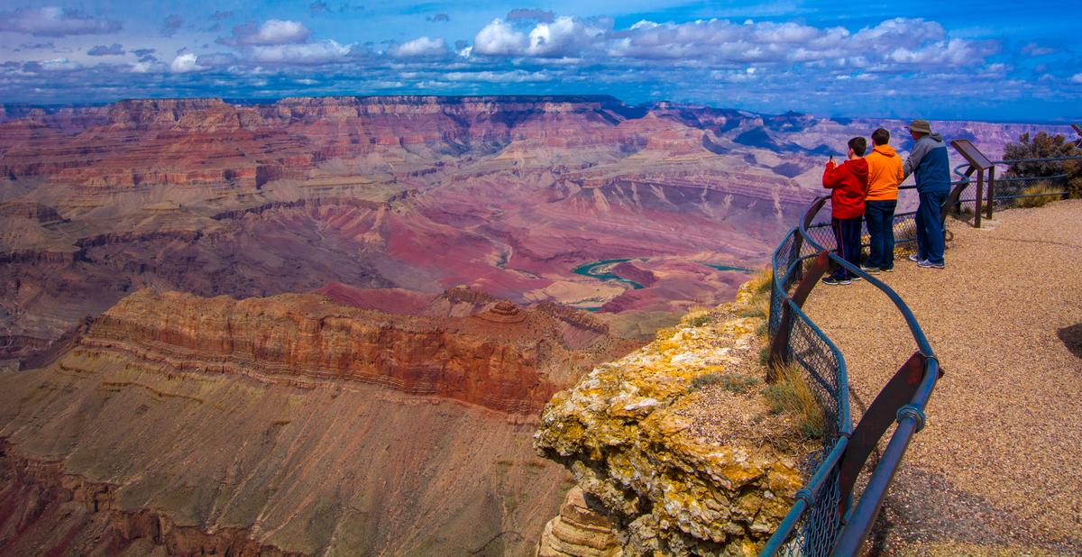
Grand Canyon
This road trip to the Grand Canyon was honestly a dream come true and felt like one of the best experiences we’ve had together.
We started our trip driving from our home base in Flagstaff, and the moment we entered Grand Canyon National Park near the South Rim’s it already felt like magic.
First thing we did was check into El Tovar Hotel, which is right on the rim and such a historic gem with an interesting, almost fairytale vibe.
The location alone is the absolute best, because you can literally walk outside and see the canyon in my photos kind of views.
After dropping our bags, we wandered along the South Rim trail and it was spectacular, vibrant, and honestly overwhelming in the best way.
Seeing the layers and colors for the first time was amazing and felt unreal, like a hidden natural masterpiece.
Later that afternoon we grabbed a relaxed lunch nearby and just kept saying how this was one of the most underrated family or romantic trips ever.
As the sun started to go down, we headed back toward El Tovar for sunset and that was easily my favorite moment.
The colors changing over the canyon felt joyful, exciting, and totally unique compared to anywhere else we’ve been.
Dinner at the hotel felt classic and cozy, and staying somewhere this historic was such a cool and unusual experience.
The night was quiet and peaceful, which made the whole stay feel like a true weekend escape.
In the morning we woke up early, grabbed coffee, and walked straight to the rim again which was a brilliant idea.
The sunrise views were breathtaking and one of the best sights in the entire park.
Before leaving, we explored more viewpoints along the South Rim and every stop felt exceptional and different.
What I loved best:
Evenings were a personal highlight, while watching the sky turn lavender and stars come out over the rim.
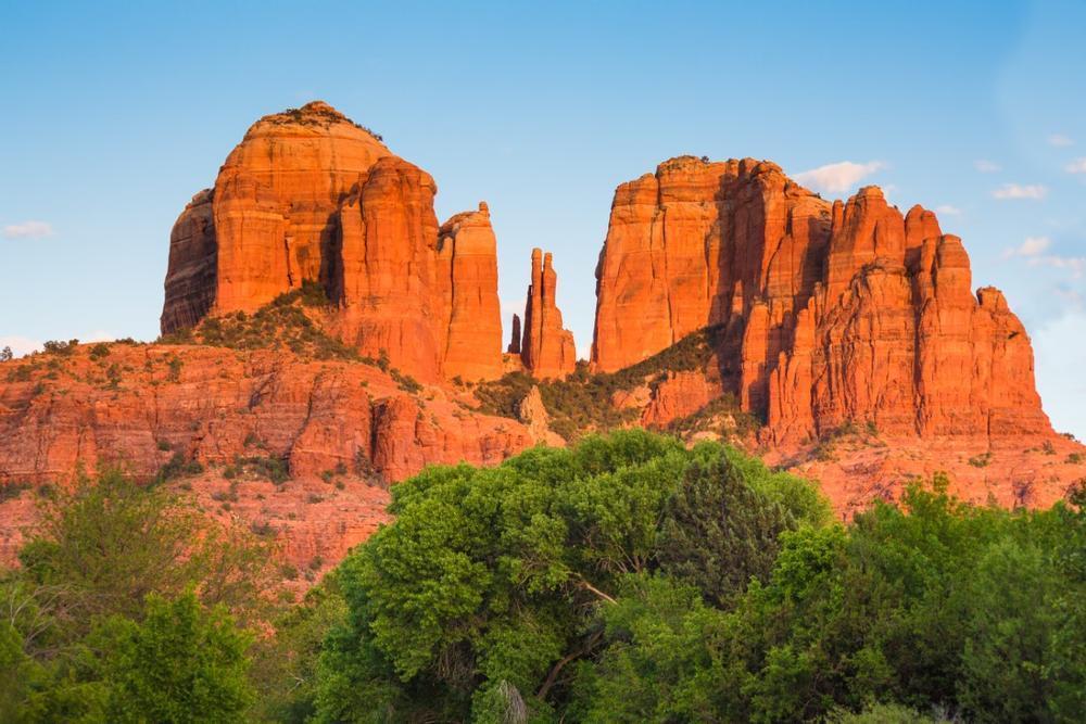
Sedona
This has to be one of my absolute favorite Arizona day trips, and every time I visit, I feel like I’ve discovered a new hidden gem in the desert. There are heaps of amazing things to do here!
We drove about 2 hours north from Phoenix to Sedona (population 9,700), long regarded as a sacred landscape by the Yavapai and Apache people. Since there is so much to take in, we decided to join a guided tour with a local guide on our first visit which was a great idea.
Just about two hours north of Phoenix, it’s an easy and affordable getaway that offers some of the most spectacular red rock views I’ve ever seen.
I loved hiking Cathedral Rock at sunrise—seeing the glowing cliffs was such a magical experience that felt like stepping into a dream.
My favorite part of the trip was exploring Oak Creek Canyon, where the water, the trees, and the vibrant colors created such a cool contrast to the desert around it.
I also found the Chapel of the Holy Cross to be one of the most unique and unusual landmarks in Sedona—it’s built right into the rocks, and the views are absolutely breathtaking.
We stopped in Uptown Sedona for shopping and lunch, and I thought the mix of local art galleries, southwestern jewelry, and cozy cafes made the whole vibe joyful and exciting.
I couldn’t resist the Pink Jeep Tour, and honestly, it was the coolest adventure—bumpy, fun, and showing us hidden corners of the red rocks I would never have seen on my own.
What I loved best:
For me, the absolute best way to end the day was watching the sunset at Airport Mesa, where the whole sky turned shades of orange, pink, and purple—it was a spectacular moment I’ll never forget that completely won me over.
Payson
Sitting beneath the edge of the Mogollon Rim, this is one of the most beautifully unspoiled mountain landscapes I’ve explored in Arizona, and I think it’s one of the best nature escapes in the state.
I loved how it had a laid-back, small-town vibe mixed with Western heritage and a strong outdoors culture. It sits in central Arizona, surrounded by the largest stand of ponderosa pines in the world, and is home to around 10,000 people today.
I explored the Tonto Natural Bridge State Park (a spectacular limestone arch), wandered through the historic Main Street with its old-west style shops, and hiked on the trails at Horton Creek with waterfalls tumbling through the forest.
I also learned about local Native American history at the Rim Country Museum, spotted wild elk in the meadows, and took a scenic drive up to the Mogollon Rim Road for sweeping views across the high country.
We stayed at 3-star Kohl's Ranch Lodge for three days.
What I loved best:
I enjoyed stargazing under the famously dark skies, a real standout.
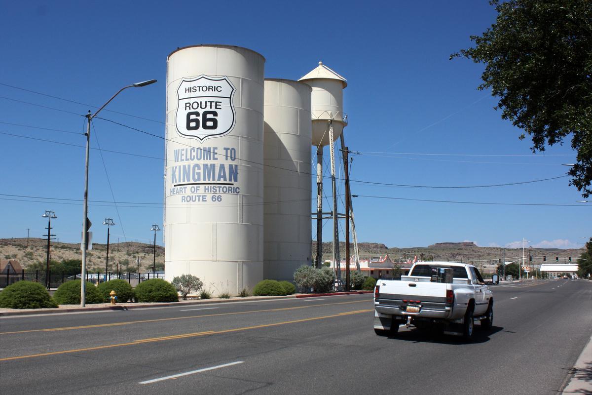
Kingman
Ready for a history-rich Route 66 escape? This high-desert town, surrounded by rugged peaks and classic Americana, is one of my favorite places to visit when I want a day packed with variety.
I instantly thought our journey was worth it! My days were filled with exploring the Route 66 Museum, where old photographs and gleaming classic cars told the story of America’s great road adventure, and wandering through the revitalized downtown lined with murals and cozy diners. The surrounding Mojave landscape offered scenic hikes and views that stretched to the horizon — wild, vast, and unforgettable.
What I loved best:
Evenings were cinematic and my favorite highlight — the kind of dusky calm that makes you want to sit on the hood of your car and watch the stars appear one by one.
After driving in along Historic Route 66, I checked into El Trovatore Motel for two relaxing day, a retro-style motel that felt like a step back in time, complete with neon lights and vintage charm.
Best Day Trips in Southern Arizona
Southern Arizona delivers rewarding adventures that are easy to experience in just one day.

Willcox
There’s something about this town that instantly made me feel like I’d uncovered a desert gem tucked away in southeastern Arizona. Surrounded by open plains, volcanic peaks, and dramatic skies, Willcox has a quiet magic that sneaks up on you, and it quickly became one of my favorite affordable day trips in Arizona. I thought it truly was an underrated destination—warm, scenic, and full of that wide-open Arizona wonder!
Just an hour’s drive east of Tucson, Willcox became my base for two easygoing days. My days were spent wandering the historic downtown—with its Rex Allen Museum (honoring the hometown “Arizona Cowboy”), browsing antique shops, and sampling local vintages at downtown tasting rooms. Willcox is, after all, the heart of Arizona’s wine country, with most of the state’s grapes grown in the surrounding Sulphur Springs Valley. After we relaxed on the outdoor patio at Zarpara Vineyard, I loved strolling around the vineyard on a spring afternoon.
In the afternoons, I drove out to the serene Chiricahua National Monument, where rhyolite rock pinnacles form a fantasy-land of stone.
I stayed at the 2-star Arizona Sunset Inn & Suites for two days, waking to sunrises over the Dos Cabezas Mountains.
What I loved best:
Evenings were my personal highlight because they meant barbecue joints, friendly saloon chatter, and stargazing under pristine desert skies.
Green Valley
This is one of my favorite underrated gems in the southern part of the state, and every visit feels both relaxing and inspiring.
My first stop is the Green Valley Farmers and Artisans Market, the largest and longest running marketplace in the area. Every Wednesday morning, the market comes to life with a wide array of local small food businesses and artisans and you can walk through the large marketplace and discover beautiful jewelry, unique artisan goods, and southwest products for their taste buds and home.
Just about half an hour south of Tucson, it’s an affordable and easy getway that combines small-town charm with some of the most unique desert experiences.
I loved exploring the nearby Titan Missile Museum—its such a cool and unusual place where you can actually step into a real Cold War missile silo and learn fascinating history.
One of the best parts of Green Valley for me was the proximity to Madera Canyon, a hidden gem filled with pine trees, streams, and incredible birdwatching—it felt like a magical escape from the desert heat.
We also enjoyed golfing at one of the many local courses, and the spectacular mountain views made the whole experience joyful and relaxing.
My favorite cultural stop was Tubac, just a short drive away, where the vibrant art galleries, shops, and historic mission created such an exciting and creative atmosphere.
I couldn’t resist sampling the local food, and I thought the Mexican restaurants here were some of the absolute best—affordable, authentic, and delicious.
What I loved best:
For me, the coolest surprise was how peaceful this place felt at night, with brilliant desert skies perfect for stargazing.
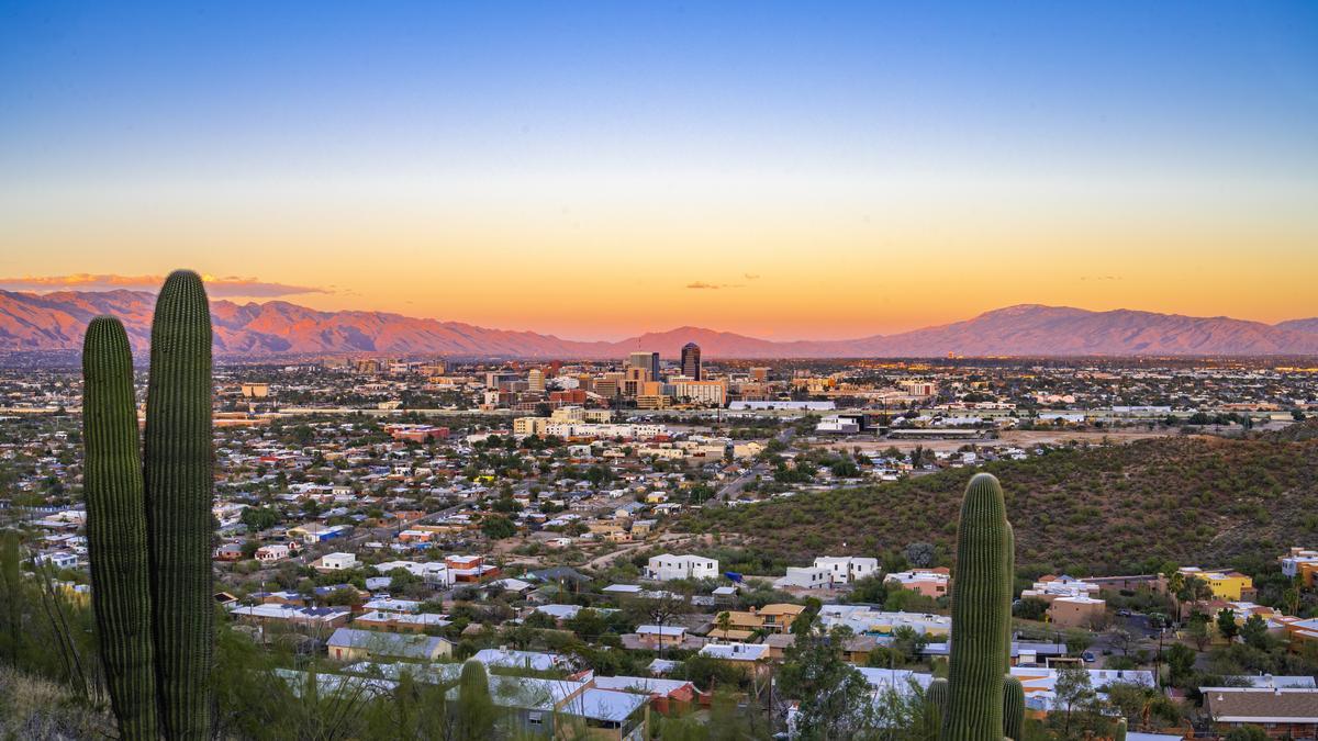
Tucson
Ready for a history-rich desert escape? Check out Tucson, a real standout! Just a couple of hours south of Phoenix, this city is surrounded by stunning mountains and desert landscapes, making it an affordable and spectacular day trip or weekend escape.
We drove about 2 hours southeast from Phoenix to Tucson, a city with roots stretching back more than 4,000 years.
One of the coolest ways I explored the city was on a Tucson Bike Tour, which gave me the chance to see historic neighborhoods, colorful murals, and hidden gems I would have missed otherwise.
I loved stopping by the Philabaum Glass Gallery & Studio, where the unusual and vibrant glass art left me in absolute awe—it’s such an underrated gem that feels both creative and inspiring.
My favorite experience was spending the day at the Arizona-Sonora Desert Museum, a mix of zoo, botanical garden, and science center that gave me the absolute best insight into desert life.
We also ventured into Saguaro National Park to hike among the towering cacti, and the views were so magical and unique that I’ll never forget them.
In downtown Tucson, I found joyful energy everywhere—from quirky shops and vibrant street art to some of the most delicious tacos I’ve ever had. I have to warn you, though, that parking can be a challenge!
What I loved best:
For me, the absolute best way to end the trip was heading up to Mount Lemmon for stargazing—the night sky was brilliant, cool, and spectacular.
Best Day Trips in Central Arizona
This region is one of my favorites because it makes it so easy to turn a free day into a well-rounded adventure.

Mesa
This is one of my favorite underrated places to visit in Arizona, a joyful mix of culture, food, and outdoor adventure.
We drove about 25 minutes east from Phoenix to Mesa, Arizona’s third-largest city.
Just east of Phoenix, it makes for an affordable and easy getaway that always surprises me with hidden gems and unique experiences.
One of the absolute best parts of my trip was starting the morning at T.C. Eggington’s, a local favorite for breakfast—the creative omelets and fresh-baked muffins were the perfect fuel for a day of exploring.
I loved spending time at the Mesa Arts Center, a vibrant hub filled with galleries, live performances, and colorful public art that gave the whole area such an exciting and creative energy.
My favorite outdoor escape was hiking at Usery Mountain Regional Park, where the desert trails and spectacular sunset views felt almost magical.
We also explored the Arizona Museum of Natural History, which turned out to be one of the coolest and most family-friendly places in town, complete with dinosaurs and interactive exhibits.
What I loved best:
The downtown area, with its murals, local shops, and affordable restaurants was my favorite highlight because it had such a vibrant and underrated vibe.
Cave Creek
Founded back in 1870, this place wowed me with its rugged desert landscapes, Wild West flair, and quirky mix of cowboy culture! Tucked into the foothills of the Sonoran Desert (Just a 40-minute day trip drive north of Phoenix!), this Arizona town is truly special, with saguaros standing tall against crimson sunsets.
We drove in early for a family day trip, and right away the desert scenery felt magical and kind of underrated.
First thing we did was wander through the town center, which felt like stepping into a western dream with a cool, vibrant vibe.
There were unique shops, rustic buildings, and art everywhere, and it honestly felt like one of the most interesting places near Phoenix.
After that we grabbed breakfast at a local cafe, which was affordable, cozy, and easily one of my favorite meals of the day.
Then we explored Cave Creek Regional Park nearby, and the hiking there was spectacular and an absolute best experience.
The desert trails felt peaceful and exciting at the same time, with cactus views you can probably see in my photos.
Later we checked out some local galleries and quirky stores, which made the whole town feel unusual and full of personality.
Lunch came next at a western-style saloon, which was such a brilliant idea and honestly one of the coolest stops.
The live music, casual food, and joyful energy made it feel like a true Arizona experience.
In the afternoon we slowed things down with a scenic drive around the area, soaking in the desert magic.
Before heading back, we stayed for sunset, which was amazing and easily my favorite moment of the entire day.
Scottsdale
Nicknamed "The West's Most Western Town", this is one of my favorite places to visit in Arizona. Why? I love how it offers a bit of everything—sunny skies, desert trails, stylish shops, and luxury resorts when I'm in the mood for some serious pampering.
We started in Old Town Scottsdale, where adobe buildings, palm-lined streets, and art-filled courtyards set the perfect backdrop for wandering together.
My favorite part was strolling through the galleries and shops, hand in hand, surrounded by colorful Southwestern art, turquoise jewelry, and warm desert textures that made the place feel both vibrant and timeless.
Downtown Scottsdale had an effortless charm, with shaded patios, fountains, and cafés that invited us to slow down and enjoy the moment.
We shared tacos at a local spot, and they were unforgettable—fresh, flavorful, and perfectly paired with a cold margarita in the afternoon heat.
I loved browsing the boutiques filled with handmade goods, desert-inspired décor, and unique souvenirs that felt meaningful rather than touristy.
A hidden highlight was heading out toward the desert at golden hour, where we watched the sun dip behind the McDowell Mountains, the sky glowing in soft pinks and oranges.
We also learned about the area’s deep Native American history and desert ecology, which gave the day a sense of place that stayed with me long after we left.
I loved exploring the McDowell Sonoran Preserve, a large, permanently protected, sustainable desert habitat. We took a guided tour and walked along desert trails surrounded by towering saguaro cacti and endless open skies.
My personal highlight was a romantic birthday dinner at Cholla Prime Steakhouse & Lounge.
On our last trip we checked into the stylish 5-star Andaz Scottsdale Resort & Bungalows for three relaxing days.
Apache Junction
Ready for a dramatic desert retreat? This is one of my favorite underrated gems on the eastern edge of the Phoenix metro area, and every visit feels both rugged and rejuvenating.
My first stop is the Superstition Mountain Museum, a fascinating introduction to the region’s Wild West history and local legends. Set against the dramatic backdrop of the Superstitions, the museum grounds showcase historic buildings, gold-rush lore, and rotating exhibits that highlight the mystery and charm of the area.
Every weekend, the nearby Mesa Market Place Swap Meet becomes a bustling scene filled with local artisans, handmade crafts, and unique desert-inspired goods. It’s easy to spend a morning wandering through the stalls, finding everything from creative décor to fresh snacks and quirky Arizona souvenirs.
Just a short drive from Phoenix, Apache Junction is an affordable and easy getaway that blends small-town friendliness with some of the most striking desert scenery in the state.
One of the most unforgettable experiences is exploring the Lost Dutchman State Park, where the rugged trails lead you through towering saguaros, wildflowers in spring, and breathtaking views of the Superstition Mountains. The park is steeped in the legend of the Lost Dutchman Gold Mine, adding an air of mystery to the landscape.
Another highlight for me was driving the Apache Trail (AZ-88)—a historic desert route that winds past canyons, lakes, and dramatic cliffs. Even just going as far as Canyon Lake feels like entering another world. The shimmering water tucked between weathered rock formations is perfect for kayaking, boating, or simply enjoying the views from the marina.
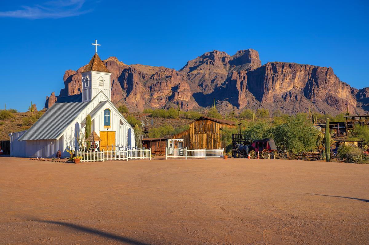
We also loved stepping back in time at Goldfield Ghost Town, a reconstructed 1890s mining town complete with live reenactments, old-fashioned shops, and a narrow-gauge railway. It’s touristy in the best possible way—fun, immersive, and full of character.
My favorite cultural stop was the Superstition Center for the Arts, where local painters, sculptors, and photographers showcase pieces inspired by the desert light and rugged mountain landscapes. The creative energy here feels vibrant and uniquely tied to the region.
Of course, I couldn’t resist the local food scene. From hearty cowboy-style breakfasts to delicious Mexican restaurants with decades-long legacies, Apache Junction offers a surprising variety of affordable and flavorful options.
For me, Apache Junction is one of the best places to visit in Arizona because it's scenic, affordable, and hope you will love it too!
What I loved best:
For me, the absolute standout was the way the Superstition Mountains glow at sunset, their cliffs turning fiery red and gold. And at night, when the city lights fade, the quiet desert skies here are a perfect spot for stargazing—peaceful, dramatic, and unforgettable.

Phoenix for Kids
This place might be Arizona’s buzzing capital, but for families, it transforms into the best playground of sunshine, discovery, and kid-friendly adventure.
I loved waking up early with my son already excited for an adventure.
First we drove about 20 minutes to the Phoenix Zoo near Papago Park, which felt like an absolute best experience for kids.
Watching my son’s face light up seeing elephants and giraffes was pure magic and honestly one of my favorite moments, see in my photos.
After that we stayed nearby and visited the Desert Botanical Garden, an underrated and interesting desert gem.
The wide paths made it easy, and the unusual cactus shapes felt unique and educational without being boring at all.
Next we headed back toward downtown Phoenix for lunch, which was affordable and perfect before the next exciting stop.
What I loved best:
Just a short stroll from downtown’s arts district brought us to the Children’s Museum of Phoenix's a wonderland for young minds and my favorite highlight. With three floors of colorful exhibits, kids could climb a towering three-story play structure, experiment in the imaginative “Pedal Power” zone, create masterpieces in the art studio, and even shop and cook in a pint-sized market. The museum’s mission—to engage minds, muscles, and imaginations—was in full swing, and I loved how every corner invited curiosity.
We flew in from Austin, TX and stayed at Arizona Grand Resort & Spa for two unforgettable days (a AAA Four-Diamond all-suite resort!).
Best Day Trips in Western Arizona
I head to this region when I'm in the mood for wide-open landscapes, river towns, and desert scenery.
Yuma
Ahh Yuma, Arizona — the sunniest city on Earth. Chris and I both absolutely love Yuma, and have been many times. This is one of my favorite desert cities to visit in the USA because it offers lots of sun, striking desert scenery, and walkable historic districts.
Tucked away in the far southwest corner of the state, Yuma might not always make the top of people’s travel lists, but that’s exactly what makes it such a cool surprise. With its rich Wild West history, dramatic desert landscapes, and location right along the Colorado River, Yuma is a fascinating destination for anyone who loves history, culture, and the outdoors.
What I love most about Yuma is how much living history it has packed into a small, easy-to-explore area. The Historic Yuma Crossing dates back centuries and played a crucial role in westward expansion. Walking through the old streets near Main Street and the riverfront feels like stepping back into the days of steamboats, soldiers, and settlers.
One spot you absolutely can’t miss is the Yuma Territorial Prison State Historic Park. Built in 1876, this infamous prison once held some of the Wild West’s most notorious outlaws. Today, you can wander the cells, guard towers, and museum while learning about frontier justice — all with sweeping views of the Colorado River.
And speaking of the river, it’s a huge part of Yuma’s charm. Whether you’re kayaking, walking the riverfront trails, or just relaxing at sunset, the contrast between the water and the surrounding desert is stunning. Add in palm trees, historic bridges, and near-constant sunshine, and it’s hard not to fall in love with the place.
Yuma is about 3 hours from Phoenix and just over 2 hours from San Diego, making it an easy road trip destination if you don’t mind desert driving. Parking is plentiful, traffic is minimal, and most attractions are very affordable.
What I loved best:
My personal highlight was strolling through the farmers market and picking up tasty snacks.
I settled into the 3-star Hilton Garden Inn overlooking the river.
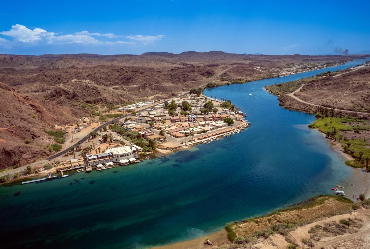
Parker
This place charmed me with its laid-back river-town vibe, sun-drenched desert backdrop, and adventurous spirit along the Colorado River. Parker is pure Southwestern oasis—where palms and speedboats outnumber pines and horses.
Just a 2.5-hour drive west from Phoenix (about 45 minutes south of Lake Havasu City) brought me to this small but lively community perched on the Arizona–California border.
Now I have to admit that as a non-local, I didn’t know much about Parker beyond hearing it mentioned by people heading to the river for the weekend.
Unlike big Arizona cities, Parker feels quiet and unhurried, but it has a strong sense of identity shaped by the river and the surrounding Native American communities. The town is located within the Colorado River Indian Tribes reservation, and this influence can be felt in local culture, events, and history. It’s a place where desert landscapes meet water recreation, creating a unique contrast you don’t see everywhere in Arizona.
What I like about Parker as a day trip is how easy it is to enjoy the outdoors without needing a packed schedule. Many visitors come for the Colorado River, which is perfect for boating, swimming, kayaking, or simply relaxing along the shoreline. Even if you’re not getting in the water, walking along the riverbanks and watching boats drift by is a great way to spend a warm afternoon.
If you’re interested in history, the Colorado River Indian Tribes Museum is worth a visit. It offers insight into the heritage, traditions, and history of the Mohave, Chemehuevi, Hopi, and Navajo peoples of the area. It’s a small museum, but it adds important context to the land you’re exploring and makes for a meaningful stop during your visit.
Parker is also close to Buckskin Mountain State Park and River Island State Park, both of which offer easy hiking trails, picnic areas, and excellent river views. These parks are ideal if you want a quieter alternative to busier Arizona destinations, especially during cooler months.
What I loved best:
Parker is one of my favorite day trips in Arizona.
Once you’ve spent time outdoors, downtown Parker keeps things simple with local diners, casual restaurants, and riverfront spots where you can grab a bite and cool off.

