
-
What is Thor’s Well?
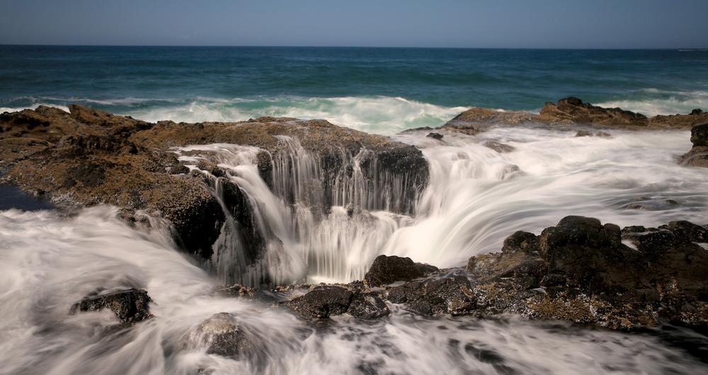
- Thor's Well is a collapsed sea cave off the coast of Oregon in the Pacific Ocean. The geographical oddity is a favorite among tourists and photographers due to the optical illusion it creates, making the ocean appear as if it is draining into a bottomless hole.
-
How deep is Thor’s Well?
- Despite the optical illusion, the “drain” of Thor’s Well is in fact just 20 feet deep.
-
Where is Thor’s Well located?
- The well is located approximately 3 miles south of the town of Yachats in the Cape Perpetua Scenic Area. Cape Perpetua is a forested headland on the Pacific coast, part of the Siuslaw National Forest. These forested cliffs overlook the rocky basalt coastline.
-
How does the optical illusion of Thor’s Well work?
- During high tide, waves roll in from the underside of the bowl-shaped feature, causing water to spurt forcefully from the top. As the water recedes, the ocean appears to be draining. This cycle continues as Thor’s Well fills and drains with each wave.
-
Can visitors see Thor’s Well at low tide?
- At low tide, while the rocks are mostly uncovered, visitors can observe how the optical illusion works.
-
Is Thor’s Well dangerous?
- Although Thor’s Well is no more dangerous than the surrounding ocean, visitors are urged to be cautious. The volcanic rock is sharp and slippery, and tourists have been caught off guard and toppled by rogue waves at high tide.
-
Why is Thor’s Well popular?
- Despite the risks, it is a popular spot for viewing, especially among amateur and professional photographers.
This post may include affiliate links. Click here for Affiliate Disclosure.
1. Thor’s Well History

© wollertz/stock.adobe.com
-
How was Thor’s Well formed?
- The well most likely began as a sea cave, which is formed by the force of the ocean and its gradual erosion of the rock. At some point, the ceiling of the sea cave collapsed, creating the appearance of a hole in the ocean.
-
How does Thor’s Well create its dramatic effect?
- The ocean surges and sprays from the openings at the top and bottom of the collapsed cave, creating the dramatic appearance of draining or spouting.
-
What are some nicknames for Thor’s Well?
- Over the years, Thor’s Well has earned the dramatic nicknames of “Gate to Hell” or “Drainpipe of the Ocean”, but visitors at low tide can clearly see there is no such bottomless drain.
-
What is the history of the Cape Perpetua area?
- The Cape Perpetua area has been home to Native Americans for close to 6,000 years. The Alsea peoples hunted in this area for mussels, clams, sea urchins, and crabs.
-
What evidence of Native American presence remains at Cape Perpetua?
- Today, one can see evidence of their presence in the large amounts of discarded mussel shells surrounding the Cape Perpetua Visitor Center.
-
How did Cape Perpetua get its name?
- In the Alsea native language, the area was named “Exposed Place.” The site was named Perpetua by Captain James Cook on St. Perpetua Day in 1778, when he arrived searching for a Pacific entrance to the Northwest Passage.
-
What is the Siuslaw National Forest?
- Over 200 years later in 1908, Cape Perpetua became part of the Siuslaw National Forest. The forest covers over 630,000 acres from the Oregon coast to the Oregon Coast Range.
-
What activities can visitors do in the Siuslaw National Forest?
- Visitors to the National Forest may camp, fish, or enjoy the trails for hiking, horseback riding, mountain biking, or off-road recreational vehicle use.
2. Visit at High Tide
© Katrina Brown/stock.adobe.com
-
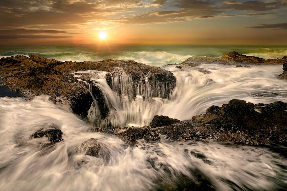
When is the best time to visit Thor’s Well?
- For the best viewing of Thor’s Well, visitors should time their visit to arrive at high tide.
-
Where can visitors park when visiting Thor’s Well?
- Limited parking is available at the Cook’s Chasm pull-out off Highway 101 in the Siuslaw National Forest, less than half a mile south of the Cape Perpetua Visitor Center.
-
What facilities are available at the Cape Perpetua Visitor Center?
- The visitor center at Cape Perpetua has an ocean viewing deck and offers extensive exhibits on the culture and natural history of the area.
-
What interactive features does the Cape Perpetua Visitor Center offer?
- The visitor center provides interactive exhibits for children, a theater, and a bookstore.
-
Are there hiking trails at Cape Perpetua?
- Hikes that begin at the visitor center lead to tide pools along the coastline or to cliffs overlooking the ocean with stunning views.
-
When is the best time to see migrating whales at Cape Perpetua?
- During the months of December and March, the area is popular for the viewing of migrating whales.
3. What’s Nearby

© MISHELA/stock.adobe.com
-
What other natural features are near Thor’s Well?
- Adjacent to Thor’s Well are additional oddly shaped features of the volcanic basalt rock. These include Cook’s Chasm, which creates a Sprouting Horn of water driven by the power of the ocean tide, and Devil’s Churn, a long crack in the rocky coastline where outgoing and incoming waves collide and explode upwards.
-
What is Cook’s Chasm?
- Cook’s Chasm is a rocky inlet where ocean waves create a Sprouting Horn—a powerful burst of water forced upward by the incoming tide.
-
What is Devil’s Churn?
- Devil’s Churn is a long, narrow crack in the coastline where waves repeatedly crash and explode, sending water high into the air.
-
Where is the town of Yachats, Oregon?
- The town of Yachats is located two miles north of Thor’s Well along the Oregon coast.
-
What are some recognitions Yachats has received?
- In 2007, Yachats was named among the 10 Coolest Small Towns in the US by Budget Travel Magazine. In 2011, the founder of Frommer’s Travel Guides cited it as number 7 of his 10 favorite travel destinations in the world.
-
What is the historical significance of Yachats?
- The area has been occupied for at least 1,500 years by the Alsea tribe and is rich in history.
Highway 101, Yachats, OR 97498
Plan Your Trip
Table of Contents: